


Alithini, Phaistos
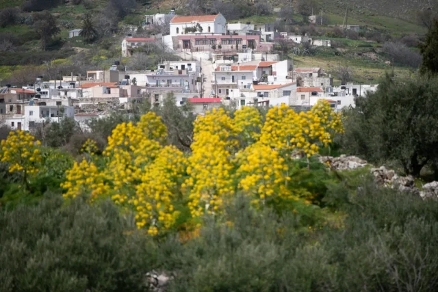
Alithini is a village in Crete's Messara plain, known for olive and cereal cultivation. Located near Moires at 150 meters altitude, its history is tied to the plain's agricultural past, potentially dating back to Minoan times. The village church, dedicated to the Dormition of the Theotokos, is a focal point. Population data shows fluctuations, with around 150 residents currently. Alithini maintains its traditional Cretan village character while adapting to modern life.

Apesokari Tholos tombs
The Apesokari Tholos Tombs in Crete are significant Early Minoan burial sites. Tholos Tomb A features a unique circular burial chamber and annex, used for both primary and secondary burials. Tholos Tomb B includes multiple rooms with evidence of communal drinking and larnax burials. Both tombs offer valuable insights into Early Minoan funerary practices and social organization.

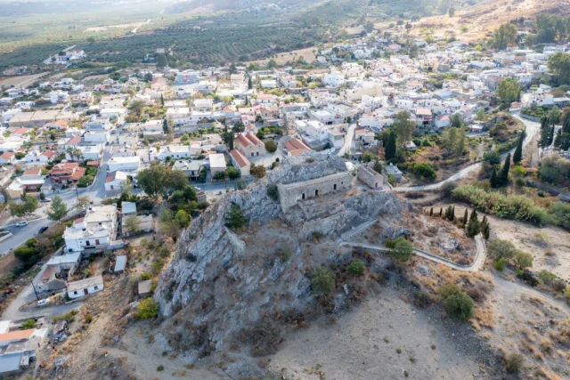
Charakas Fortress
Charakas Fortress, located on the Charaki rock in Crete's Asterousia Mountains, features Venetian fortifications built over a Middle Byzantine site. Visible remnants include a main building with three vaulted chambers, two rectangular towers, and the Church of the Transfiguration of the Savior. The fortress, strategically positioned for panoramic views, was likely constructed in the 14th century and later abandoned during Ottoman rule. The western side, the most accessible, is fortified with a double perimeter wall, while the eastern side's cliffs offered natural defense. Architectural details include rainwater collection systems and lime mortar floors carved into the rock. The site reflects the region's medieval history and Venetian defensive strategies.
Demati, Minoa - Pediada
Demati, a village in the Heraklion regional unit on the island of Crete, Greece, is located in the foothills of Mount Chousakas in the Asterousia Mountains. The village, accessible via a branch road near the Anapodaris river, has a history dating back to the Venetian era. First recorded in 1577 as "Dhemati", the village was once home to both Muslims and Christians. Today, Demati's inhabitants are mainly involved in olive growing and viticulture. The village has a primary school, a kindergarten, and several notable landmarks, including the Church of the Holy Cross, the Church of Agios Georgios, a 15th-century Byzantine monastery, the Anapodaris gorge, and a Venetian bridge.

Gerokampos Tholos Tomb
The Lebena Gerokampos Tholos Tomb is an Early Minoan I-II (c. 3100-2600 BCE) archaeological site located near Lentas, on the southern coast of Crete, close to the ancient Minoan settlement of Lebena. The tomb, with an interior diameter of approximately 5 meters, is typical of tholos tombs, with a circular chamber built of large stones and a corbelled vault. The tomb also features several smaller chambers or annexes, which were added later. These annexes, along with the main tholos, served as spaces for burial and ritual activities. A large quantity of pottery, including pyxides, tankards, cups, and bowls, was found in the tomb. The tomb contained the skeletal remains of numerous individuals, providing evidence of collective burial practices. Other significant finds from the tomb include jewelry, tools, and figurines.
Kaloi Limenes beach
Kaloi Limenes, in Heraklion, Crete, is a coastal settlement with a natural harbor. The area is known for its rugged beauty and proximity to Lentas and the ancient city of Lasaia. A small islet named "Apostolos Pavlos" is located in the harbor and a nearby church is dedicated to Apostle Paul. The name Kaloi Limenes appears in the Acts of the Apostles and is associated with Apostle Paul's journey. During the Venetian era, it was known for smuggling activities.
Koumasa, Gortyna
Koumasa, a Cretan village with a long history, is located in the Gortyna municipality on the foothills of the Asterousia Mountains. It is known for its archaeological sites, including tombs and settlements from various Minoan periods.
The village's history dates back to at least 1368 during the Venetian period. The name "Koumasa" likely comes from the word "koumos," meaning a temporary shelter for animals.
A research program led by Professor Diamantis Panagiotopoulos is currently excavating and studying the settlement and necropolis. Discoveries include a Pre-palatial and Old Palace period necropolis, a New Palace period settlement, and an Early Minoan underground burial deposit.
With 69 inhabitants, Koumasa maintains a tranquil atmosphere. The village continues its agricultural traditions, while the archaeological research attracts visitors.

Lebena (Leveen)
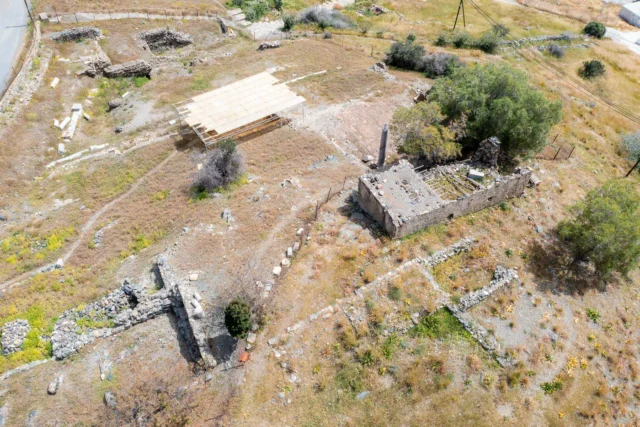
Lebena, an ancient city on Crete's southern coast, is renowned for its Sanctuary of Asclepius, the Greek god of medicine. The city's strategic location near a good harbor and its association with the healing cult of Asclepius made it an important center for both trade and religious pilgrimage. Lebena was also a significant port for trade and commerce with the East during the Prepalatial period. The site of Lebena has a long history of occupation, with evidence of inhabitation dating back to the Neolithic and Early Minoan periods (ca. 3rd millennium BC). The presence of a variety of Eastern imports in secure Prepalatial contexts at Lebena, including faience, gold, ivory, and Egyptian scarabs, suggests that Lebena was a significant port for trade and commerce with the East during this time. In the Late Classical period (ca. 4th century BC), the Gortynians established the sanctuary dedicated to Asclepius at the harbor. The city was destroyed by a powerful earthquake in 46 BC but was subsequently rebuilt. The sanctuary continued to flourish throughout the Roman period, as evidenced by the numerous inscriptions and archaeological finds from the site. The strategic location of Lebena on the south coast of Crete made it an ideal location for a port. The sheltered bay would have provided a safe harbor for ships, and the proximity to the Asterousia Mountains would have offered protection from storms. Additionally, Lebena's location on the south coast would have made it a convenient stopping point for ships traveling between the Aegean and the Near East. The presence of Eastern imports at Lebena suggests that the site was an important point of contact between Crete and the East during the Prepalatial period.


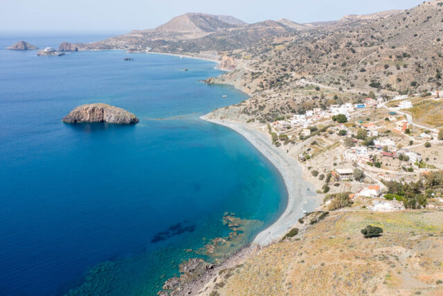
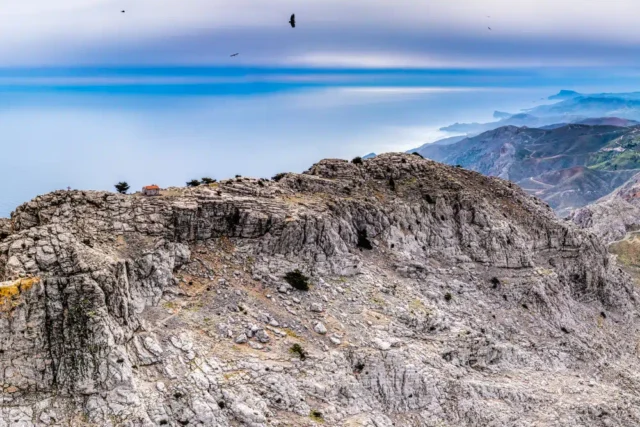
Lithino Cape, Kefali peak
Lithino Cape, the southernmost point of Crete, features a rugged landscape with cliffs and remnants of WWII German fortifications. The cape's strategic location, offering a commanding view of the southern coastline, led the Germans to construct these fortifications to defend against potential invasion. Mount Kefali, situated on the cape, rises to an elevation of 388 meters and offers stunning views of the coastline, Gavdos, and the Asterousia Mountains. Atop Kefali Peak stands the small stone church of Timios Stavros, a testament to the site's enduring importance as a place of worship and refuge. The ruins of pillboxes built by the Germans during the Second World War are a stark reminder of the cape’s strategic value.
Loukia, Gortyna
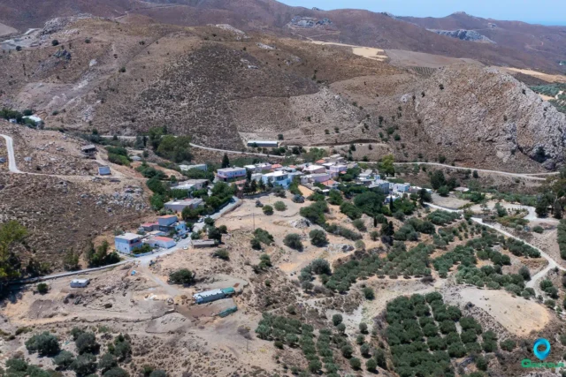
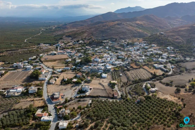
Loukia, located in the Asterousia Mountains of Crete, is a village with a rich history dating back to at least 1368. Records indicate its existence under both Venetian and Ottoman rule. The village, situated 67 kilometers south of Heraklion, has a population of 155. Loukia features traditional architecture, some of which is in disrepair. Despite its small size, the village maintains a primary school, churches, and a cultural association dedicated to preserving its heritage.


Minoan Archaeological Site at Odigitria Monastery
The Odigitria Cemetery in Crete's Asterousia mountains is an archaeological site dating back to the Early Minoan (EM) period.
It features two tholos tombs (A and B), a Rectangular Building, courtyards, an ossuary, and a possible altar, all enclosed within a peribolos wall. The site's three construction phases span from the Final Neolithic to the Middle Minoan (MM) era. Tholos A, the smaller of the two tombs, contained undisturbed EM I pottery, while Tholos B boasts a unique complete outer wall. The Rectangular Building may have served as an independent burial building or ritual space. The courtyards, particularly the Eastern and Outer Courtyards, likely hosted rituals associated with the deceased. The ossuary reveals the practice of secondary burial, where bodies were initially interred in the tholos tombs or pithoi and later transferred to the ossuary. The Odigitria Cemetery provides significant insights into Early and Middle Minoan burial practices, social structures, and material culture.


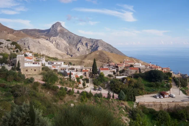
Paranymfoi, Archanes - Asterousia
Paranymfoi is a small, picturesque village nestled in the Asterousia Mountains of Crete, with a history stretching back to the 13th century. The village is mentioned in Venetian records and Ottoman censuses, bearing testament to its long history. The rugged terrain has contributed to a strong sense of community and self-reliance among its inhabitants, who have traditionally been involved in agriculture and animal husbandry.
Paranymfoi's strategic location made it an important stopover for travelers and traders in the past. Today, it continues to attract visitors with its stunning panoramic views, which include the Libyan Sea. The village also serves as a starting point for exploring the Asterousia Mountains, offering a unique blend of natural beauty and historical significance.
A small folklore museum, established by the local cultural association, showcases the traditional way of life in the region. The museum houses a collection of old objects used in weaving, storage, agricultural work, and various household items. The church of Agios Pavlos, with its remnants of frescoes, stands as a reminder of the village's rich past. Paranymfoi's enduring presence and unique character make it a hidden gem in the tapestry of Cretan history.

Platanos Minoan tholos tombs
The Minoan tholos tombs at Platanos, located in the Messara Plain of Crete, are significant archaeological remains from the Prepalatial period (c. 3200-2000 BC). Excavated in the early 20th century, the site features three tholos tombs (circular, beehive-shaped burial chambers) and a paved courtyard. The tombs, labeled A, B, and C, vary in size and preservation. Tomb A, the largest, has an internal diameter of 13 meters. The tombs contained many artifacts, including seals, figurines, pottery vessels, stone vessels, gold jewelry, and bronze tools. These findings provide valuable insights into Minoan funerary practices and material culture during the Prepalatial period. The presence of imported objects, such as an ancient Babylonian cylinder seal and Egyptian scarabs, also highlights the extensive trade networks that connected Crete with other civilizations in the Eastern Mediterranean.
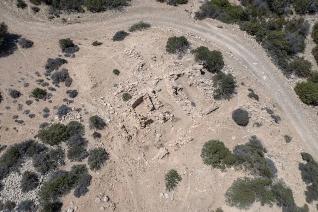
Skaniari Lakkos
Skaniari Lakkos, a Minoan cemetery complex located in the Asterousia Mountains of southern Crete, provides valuable insights into Minoan burial practices and social organization during the Bronze Age. It features five distinct burial structures, including two tholos tombs and three rectangular buildings, each containing multiple chambers and showcasing a variety of architectural styles. These structures date back to the Final Neolithic period (c. 3500 BC) to the Middle Minoan IB period (c. 1900 BC). Excavations at Skaniari Lakkos have yielded a wealth of artifacts, including pottery vessels, stone tools, jewelry, and seals, providing information about Minoan material culture, artistic expression, and trade networks. The presence of imported goods suggests connections with other regions in the Aegean and beyond. The site's remote location and the monumental nature of the burial structures underscore the importance of death and the afterlife in Minoan society. Skaniari Lakkos is part of a broader network of Minoan settlements and burial sites in the Asterousia region, including Trypiti, Doukiania, and the tholos tombs of Kefali and Moni Odigitria.
Sternes, Gortyna
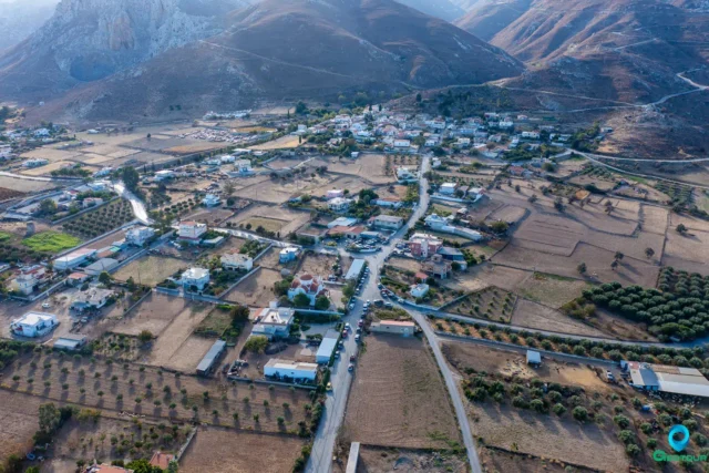
Sternes, a village in Heraklion, Crete, has a history dating back to the 13th century. Its name comes from the Greek word "sterna," meaning cistern, referencing a large Roman-era cistern located west of the village.
Sternes is in the foothills of the Asterousia Mountains. The village has been documented in historical records as early as 1271. Today, Sternes remains an agricultural community with a population of around 420, focused on the cultivation of olives and grapes for raisins.
Sternes has several churches and chapels, including the church of the Presentation of the Virgin Mary, the church of Saint John, and the chapels of Agia Paraskevi and Panagia. The village also has a cultural association, a kindergarten, and an elementary school.

Trypiti beach
Located on the southern coast of Crete's Heraklion prefecture within the Asterousia Mountains, approximately 57-73 km south of Heraklion city and 12 km east of Lendas. It sits at the exit of the Tripiti Gorge. The name relates to local geology and the Panagia Tripiti chapel cave. Access involves unpaved dirt tracks from Lendas or Vassiliki, often requiring a 4x4 vehicle, particularly the route through the narrow final gorge passage. The 400m beach features fine pebbles, clear, calm waters sheltered by Cape Fylakas, though it deepens quickly offshore. Tamarisk trees and cliffs offer shade. Despite difficult access, it's popular with locals and can be crowded. Basic tavernas are available, but no organized facilities exist. The area, part of Natura 2000, sees local caravan presence. Activities include swimming, snorkeling, hiking to nearby Minoan ruins of Papouri, and stargazing.
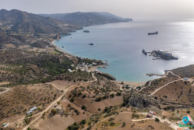
Tsoutsouras
Located on Crete's S. coast (Heraklion), 63km S. of Heraklion town at the Mindris Gorge exit near the Asterousia Mountains. Site of ancient Inatos, Priansos' port. Features a ~2km sand/pebble beach with clear, calm, shallow waters, ideal for families, shaded by tamarisk trees. Organized with amenities like sunbeds, showers, and nearby tavernas. Local tradition attributes therapeutic qualities to the water. Accessible via a paved, winding mountain road. Nearby are Pera Tsoutsouras (shallow, sandy), Maridaki (pebble, isolated, gorge access), and Listis Beach (rocks). Offers a quiet, relaxing atmosphere.

Search anytime for whatever you need, for your business, fun or personal needs. Panotours helps you find it easy and fast.
Search anytime for whatever you need, for your business, fun or personal needs. Bello helps you find it easy and fast.
Geotour website by Nikolakakis Manolis is licensed under CC BY-NC-SA 4.0
Geotour website by Nikolakakis Manolis is licensed under CC BY-NC-SA 4.0
Search & have fun
Geotour
Explore
Panotours
Search & have fun
Explore
Users
Panotours

![]()
![]()
![]()
![]()
![]()
![]()
![]()
![]()