
Katharo plateau
Situated in the Dikti mountain range of Lasithi, Crete, 26km from Agios Nikolaos, this plateau rests at 1150m altitude. Its waters flow via the Havgas Gorge to the Lasithi Plateau. Human activity dates back to the Minoan era. Ownership was historically disputed between Lasithi and Kritsa residents, eventually awarded to Kritsa after legal battles documented in Greek and Turkish archives; a legend involves a Turkish judge and the site "Kadi's Pit". Today, it's primarily used for cultivating potatoes, apples, and vineyards by Kritsa residents who lease the land. Access is via paved road from Kritsa through an oak forest, or dirt roads from Lasithi Plateau and Malles Ierapetras; the E4 trail also passes through. Points of interest include the Avdeliakos settlement, the Chapel of Afentis Christos, and Kadi's Pit. The area offers cool summer temperatures, hiking opportunities, and hosts the annual Shepherd's Festival after August 15th.
Strouboulas Massif
Located in Crete's Malevizi Province near Tylissos and visible from Heraklion, this mountain range features a prominent peak (798m) noted for its conical shape. Historically called "Stroggylo," Venetians named it after Stromboli. The range includes the Strouboulas plateau, south of the ridge, formed on limestone ("Tripoli" zone), leading to karstic features like the Tafkos tou Palmetis chasm, linked to Ottoman-era resistance. Vegetation is sparse, dominated by Kermes Oak due to overgrazing. A seasonal lake forms on the plateau, its water often reddish from soil runoff. Historical significance includes Minoan foothill settlements, the Timios Stavros chapel (Holy Cross) on the summit mentioned in 1415, possibly on an older site, and the Agios Georgios chapel ruins below, once a monastery dependency. Access to the peak involves a path from the plateau offering panoramic views.
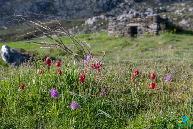
The Gious Kampos Plateau
Gious Kampos is an ecologically important high-altitude plateau (750m avg. elevation) in the Amari Valley administrative area, Rethymno, Crete, situated on the northwest side of Mount Kentros. Its geology, combining clay rocks with limestone outcrops, fosters unique hydrology and fertile soil. The name potentially derives from "Plain of Eos" (dawn) or "Plain of the Goats." Designated a Natura 2000 site, it's renowned for exceptional biodiversity, serving as the primary habitat for the protected endemic Cretan red tulip, Tulipa doerfleri. The plateau also hosts a remarkable density and variety of orchids, including Orchis italica and Neotinea tridentata. Historically and currently vital for agriculture (cereals, vegetables, fruit trees) and pastoralism for surrounding villages like Spili and Kissos.
Search anytime for whatever you need, for your business, fun or personal needs. Panotours helps you find it easy and fast.
Search anytime for whatever you need, for your business, fun or personal needs. Bello helps you find it easy and fast.
Geotour website by Nikolakakis Manolis is licensed under CC BY-NC-SA 4.0
Geotour website by Nikolakakis Manolis is licensed under CC BY-NC-SA 4.0
Search & have fun
Geotour
Explore
Panotours
Search & have fun
Explore
Users
Panotours

![]()
![]()
![]()
![]()
![]()
![]()
![]()
![]()