The Seismic Heritage of Crete: A Foundation of Instability
The cataclysmic earthquake that struck Crete on July 21, 365 CE, was an event of such magnitude that its effects rippled across the entire Eastern Mediterranean, leaving an indelible mark on the landscape and the collective memory of Late Antiquity. Yet, to fully comprehend its transformative power, one must first understand that this was not an isolated act of nature visited upon a placid world. Instead, it was the violent culmination of millennia of geological instability inherent to Crete’s position in one of the planet’s most active tectonic settings. The island’s history is a palimpsest of seismic destruction and human resilience, a long and often brutal dialogue between civilization and the very ground upon which it was built. The 365 CE event, while perhaps unparalleled in its recorded intensity, was a chapter in a much older story of a land defined by its profound and recurring instability.
The Hellenic Arc: A Tectonic Crucible
The fundamental cause of Crete’s seismicity lies in its position along the Hellenic Arc, a major convergent plate boundary that sweeps from the Ionian Islands, south of the Peloponnese and Crete, and northeast towards Rhodes and Anatolia. This arc marks the geological frontier where the oceanic crust of the African Plate subducts, or dives, beneath the continental crust of the Aegean Sea Plate, a smaller segment of the larger Eurasian Plate. This process of subduction is relentless, with the African plate moving in a northeast-southwest direction at an estimated velocity of about 2.5 cm per year, creating immense and continuous tectonic pressure.
This collision zone is not a smooth interface but a complex system of faults and trenches. The Hellenic Trench, which runs immediately south of Crete, is the surface expression of this subduction and is recognized as the zone of highest seismic activity and energy release in Europe. The constant grinding and locking of these massive plates builds up immense strain energy, which is periodically and violently released in the form of earthquakes. The energy released is quantified by magnitude scales, such as the logarithmic Richter scale, where each whole number increase represents a tenfold increase in measured amplitude and roughly a thirtyfold increase in energy. The tangible effects of this energy on the human environment—the shaking felt and the destruction observed—are measured by intensity scales, like the Modified Mercalli scale. Historically, the area around Crete has produced two earthquakes with magnitudes exceeding 8.0 on the Richter scale, placing it in the highest echelons of global seismic hazard zones. This tectonic engine not only generates earthquakes but also drives volcanism, as the subducting plate melts at depth, creating magma that rises to the surface along the South Aegean Volcanic Arc, which includes the well-known volcanoes of Santorini (Thera) and Nisyros. Crete, therefore, exists within a tectonic crucible, perpetually shaped and threatened by the powerful geological forces beneath it.
A History Written in Tremors: Seismicity Before 365 CE
The archaeological record of Crete provides stark evidence that seismic catastrophes were a recurring feature of life long before the Roman era. The island’s Minoan civilization, which flourished in the Bronze Age, was repeatedly struck by devastating earthquakes. The most compelling evidence comes from the end of the Middle Minoan IIB period, shortly after 1700 BCE, when the first great palaces at sites like Knossos, Phaistos, and Malia appear to have been destroyed simultaneously across the island. The sheer scale and synchronicity of this destruction horizon make widespread fires or human conflict unlikely culprits; a massive earthquake or a series of closely spaced quakes remains the most plausible explanation.
Specific sites offer dramatic vignettes of this prehistoric seismic violence. At Phaistos, the Old Palace was severely damaged and rebuilt multiple times, with a displaced pillar block from this period still visible as a testament to the forces involved. At Knossos, the effects of a massive earthquake around 1650 BCE (MM IIIA) are vividly illustrated by the destruction of two houses adjacent to the palace, the “House of the Sacrificed Oxen” and the “House of the Fallen Blocks,” which were crushed by enormous stones, some weighing over a ton, hurled from the palace walls. Perhaps the most harrowing evidence comes from the peak sanctuary at Anemospilia, where the skeletons of four individuals, including one who appears to have been a human sacrifice, were found buried under the collapsed temple walls, a tragedy dated to the same period of widespread destruction. These events were not isolated incidents; destruction layers attributed to earthquakes punctuate the Minoan chronological sequence, including the final destruction of the Neopalatial centers around 1450 BCE.
As civilization progressed into the historical periods, human understanding of these events began to evolve. While the earliest records of earthquakes from the Greek world, dating to no earlier than 600 BCE, are fragmentary, they reveal a critical intellectual shift. Societies moved from purely mythological interpretations, which viewed earthquakes as expressions of the wrath of gods like Poseidon, the “Earth-Shaker,” to the development of proto-scientific theories. Ionian natural philosophers in the 7th and 6th centuries BCE proposed explanations based on natural phenomena, such as a volcanic theory, a Neptunian (water-based) theory, and, most influentially, a pneumatic theory championed by Aristotle. This latter theory held that the earth was a hollow body and that earthquakes were caused by the movement of air trapped within it. By the time of the historian Thucydides in the 5th century BCE, the causal link between earthquakes and tsunamis was also clearly recognized and recorded. This intellectual framework formed the backdrop of the Roman world. Historical sources from the Christian era confirm the continued seismic threat, with “great earthquakes” recorded in Crete during the reign of Nero (66 CE) and again in 251 CE and 375 CE, demonstrating that the geological forces that had plagued the Minoans remained a potent and destructive reality for the island’s Roman inhabitants.
This long and violent seismic history is crucial for understanding the context of the 365 CE event. It fostered a landscape that was a palimpsest of destruction and renewal, where successive generations built upon the ruins of their predecessors. This recurring cycle suggests that Cretan society developed a form of inherent resilience, an ingrained capacity to recover and rebuild in the face of catastrophe. The Minoan palace destructions, for example, were often followed by periods of reconstruction on an even grander scale. However, the Roman system that the 365 CE earthquake struck was fundamentally different from that of the Bronze Age. Roman Crete was not a collection of distinct palace-centered economies but a single, integrated province within a vast empire, characterized by a long period of peace and prosperity, interconnected by trade, and administered from a central capital at Gortyn. This integrated system, while efficient, was also arguably more brittle. The failure of key nodes—the capital, the major western ports—would have had far more profound and immediate island-wide repercussions than the destruction of individual Minoan palaces. The 365 CE earthquake, therefore, struck a society that, while existing on seismically active ground, had enjoyed centuries of relative stability. The shock was not merely physical; it was a systemic blow that would challenge the very foundations of Roman life on the island.
Anatomy of a Cataclysm: The Geological and Physical Manifestation of the 365 CE Event
The earthquake of July 21, 365 CE, was not merely another tremor in Crete’s long seismic history; it was a geological event of almost unimaginable power. Modern scientific analysis, combining geological field evidence with sophisticated modeling, has allowed for a detailed reconstruction of the earthquake’s source, its immense energy release, and its immediate, dramatic effects on the physical landscape. It was a cataclysm that permanently altered the coastline of Crete and unleashed a destructive tsunami that propagated across the entire Eastern Mediterranean, an event so profound that its physical signatures remain clearly visible over 1,600 years later.
The Source: A Megathrust Rupture
The geological source of the 365 CE earthquake is now understood to have been a massive rupture on a major submarine fault associated with the Hellenic subduction zone. Based on the pattern of crustal deformation observed on Crete, scientists have modeled the causative fault as a large reverse fault, or thrust, located offshore of the southwestern coast of the island. Elastic dislocation analysis, a technique that calculates the fault parameters required to produce a given surface deformation, indicates a fault plane with a length of at least 105 km and a width of 100 km, dipping at an angle of approximately 40 degrees into the earth’s crust.
The most staggering parameter of this fault model is the amount of slip, or movement, that occurred during the earthquake, which is calculated to have been as much as 16 meters. This immense and sudden displacement generated a colossal release of energy. The seismic moment, a measure of the total energy released, is estimated to be a moment magnitude (Mw) of at least 8.5, and possibly as high as 8.6, placing the 365 CE Crete earthquake in the category of a “megathrust” event, comparable in scale to the largest earthquakes recorded in modern times. Such an event represents the release of centuries, if not millennia, of accumulated tectonic strain in a matter of minutes.
The Upheaval: Permanent Reshaping of the Cretan Coastline
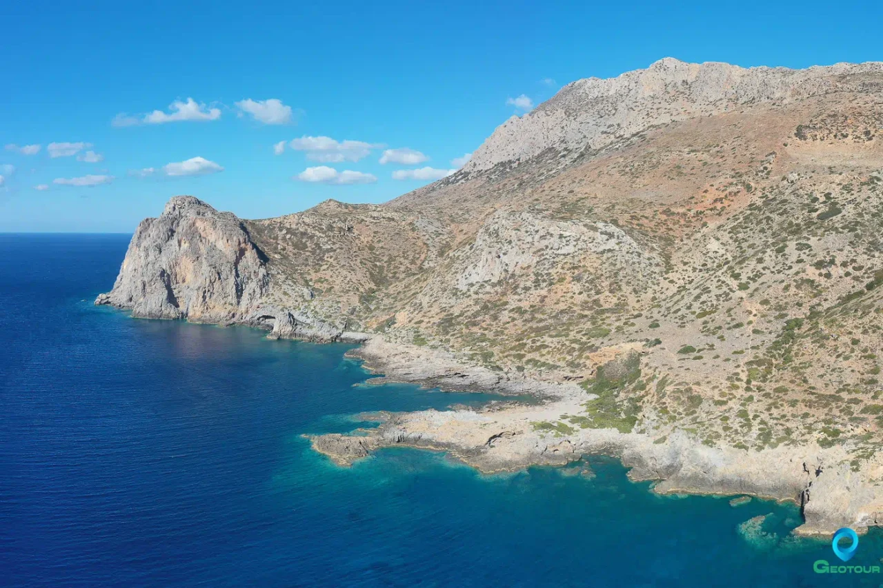
The most direct and enduring consequence of this megathrust rupture was the instantaneous and permanent uplift of the western part of Crete. This co-seismic uplift was not uniform; it was a massive tilting of the western end of the island, with the greatest vertical displacement occurring at the southwestern corner and diminishing eastward. In the region of ancient Phalasarna and the southwestern tip of the island, the land was thrust upwards by as much as 9 meters. This uplift extended across the sea to the nearby islet of Antikythera, which was raised by 3 to 3.5 meters, while the island of Kythera, further north, showed no evidence of coeval uplift, helping to constrain the location of the fault rupture.
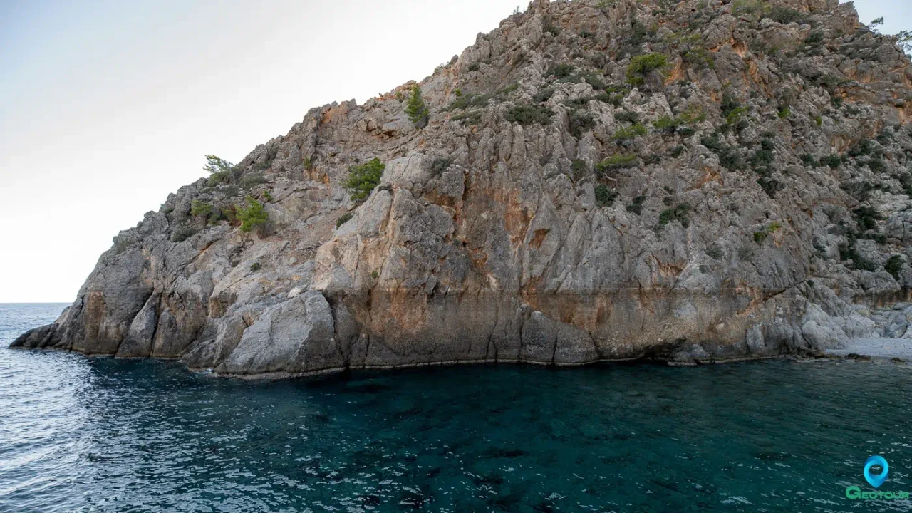
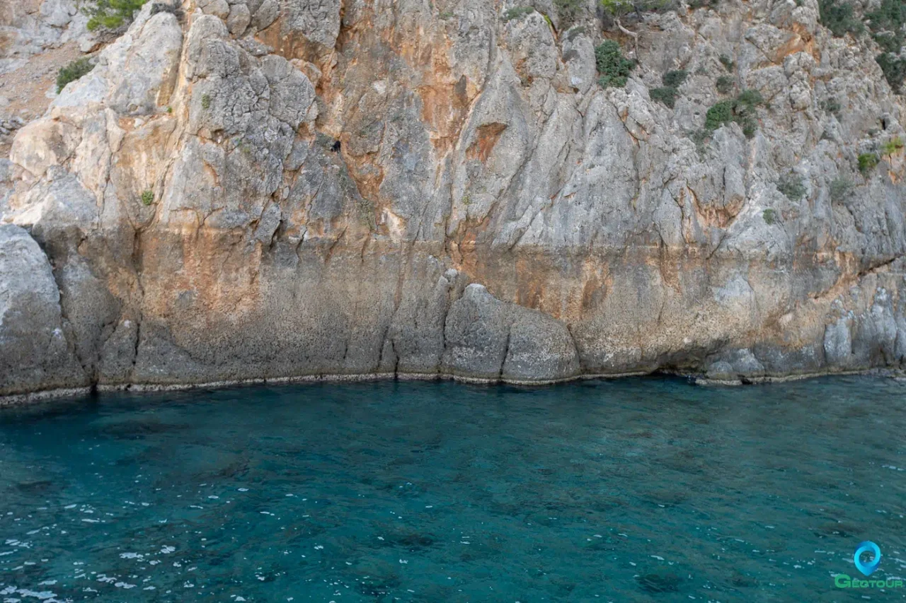
This was not a slow, gradual process but a sudden, violent upheaval. The proof lies in biological evidence: fragile marine organisms, such as Bryozoans and corals, that live in the shallow subtidal zone were lifted clear of the water so rapidly that they were preserved intact on the newly exposed rock, without being eroded by wave action in the intertidal zone. Radiocarbon dating of these fossilized organisms has been crucial in confirming that the uplift event occurred in the 4th century CE.
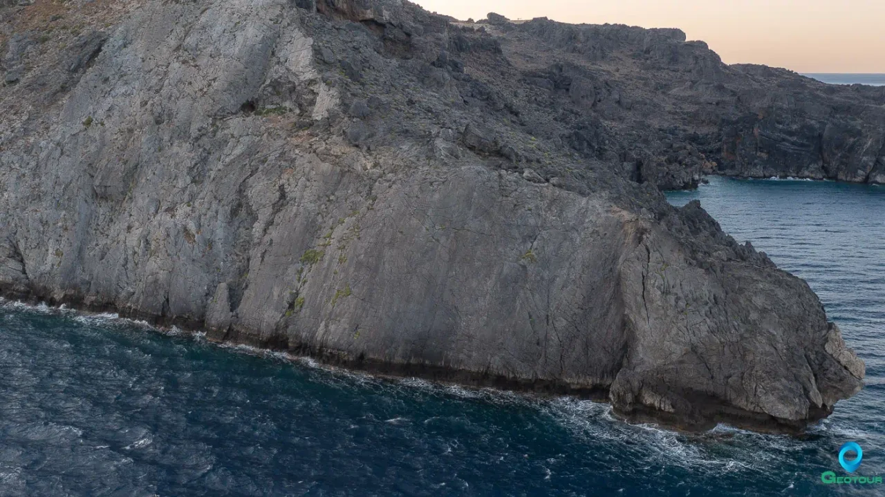
This massive geological transformation left a distinct geomorphological signature on the landscape, a feature often described as a “bath-tub ring” around the western coast of Crete. This fossil shoreline is clearly visible today as a wave-cut notch, sometimes accompanied by sea caves, that marks the former sea level but is now situated high and dry on the coastal cliffs. This dramatic and unambiguous physical evidence provides irrefutable proof of the earthquake’s scale and its profound, landscape-altering power. Scientists estimate that an uplift of this magnitude is an extremely rare event, likely to occur in the same location only once every 5,000 years.
The Deluge: The Mediterranean-Wide Tsunami
The same colossal vertical movement of the seafloor that lifted western Crete also displaced a vast volume of seawater, generating a catastrophic tsunami that radiated outwards from the source. The historical record of this event is unusually clear, thanks to the vivid account of the Roman historian Ammianus Marcellinus, who was a contemporary of the event. Writing about its effects in Alexandria, Egypt, he described the classic three-stage sequence of a tsunami: first, the violent shaking of the earthquake itself; second, the dramatic withdrawal of the sea, which exposed the seabed and stranded ships; and third, the terrifying return of a “roaring sea” as a gigantic wave that “dashed itself violently on islands and extensive tracts of the mainland”.
Ammianus’s account details the tsunami’s devastating impact on Alexandria, where the wave killed thousands, overtopped defenses, and hurled huge ships onto the roofs of houses and nearly two miles inland. The disaster left such a deep psychological scar that its anniversary was commemorated in Alexandria for centuries as the “Day of Horror”.
Modern geological research has found physical evidence corroborating the historical accounts of the tsunami’s impact on Crete itself. Along the southern coast, in places like Kommos, researchers have identified large accumulations of boulders, some weighing hundreds of tons, that have been moved and deposited in positions that cannot be explained by storm waves, even of the most extreme intensity. Radiocarbon dating of marine organisms encrusted on these boulders shows that they were in their pre-tsunami positions before the 4th century CE, strongly suggesting they were transported by the 365 CE event. In addition to these high-energy deposits, distinct layers of fine-grained sand and marine microfossils, characteristic of tsunami inundation, have been found in coastal plain sediment cores at Sougia and Palaiochora in southwestern Crete, also dated to the same period.
The 365 CE earthquake was not an isolated catastrophe but appears to have been the most violent event in a period of heightened seismic activity across the Eastern Mediterranean. Archaeological evidence reveals widespread destruction at sites in Cyprus, Libya, and Sicily, all dated broadly to the period between 350 and 450 CE. However, seismological analysis indicates that a single earthquake located off Crete, despite its immense magnitude, could not have produced the specific type of high-frequency, short-period ground shaking necessary to cause the collapse of the one- and two-story masonry buildings observed in Cyprus, more than 700 km away. Long-period waves from such a distant event might cause tall, flexible structures to sway, but they lack the energy to destroy smaller, rigid buildings. This discrepancy strongly suggests that the destruction in Cyprus, and likely in Sicily and Libya as well, was caused by separate, powerful “local” earthquakes that occurred around the same time. This clustering of major seismic events within a relatively short geological timeframe has led to the hypothesis of an “Early Byzantine Tectonic Paroxysm”. This theory posits a regional-scale reactivation of plate boundaries, where the immense stress released by the Cretan megathrust may have transferred stress to other critically loaded fault systems across the region, triggering a cascade of failures. This reframes the 365 CE event from a singular Cretan disaster into the centerpiece of a century-long regional seismic crisis, a period of widespread instability that would have profoundly compounded the social, political, and economic challenges facing the Late Roman Empire.
A Landscape of Ruin: A Site-by-Site Archaeological Assessment of the Destruction
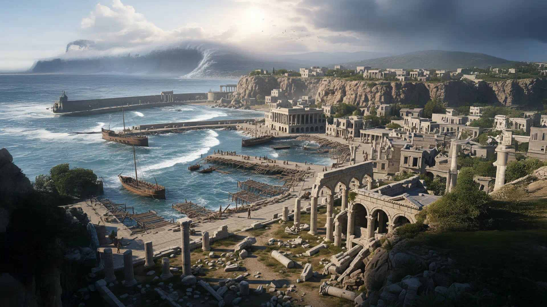
The physical violence of the 365 CE earthquake and tsunami translated into a scene of near-universal devastation across Crete. Archaeological excavations undertaken over the past century have progressively uncovered a widespread destruction layer that cuts across the island, providing tangible, often tragic, evidence of the cataclysm’s impact. From the uplifted harbors of the west to the shattered capital in the central plains, the material record speaks of collapsed buildings, buried inhabitants, and abandoned settlements. A systematic review of this evidence from key sites reveals the varied nature of the destruction and lays the essential groundwork for understanding the profound societal transformations that followed.
The Uplifted West: Harbors Left High and Dry
The most dramatic and permanent consequences of the earthquake were felt in western Crete, where the tectonic uplift fundamentally and irrevocably altered the relationship between land and sea. For the maritime communities in this region, the event was an existential blow.
Falassarna: This prominent Hellenistic port city, a key node in maritime trade routes, was effectively erased from the map as a functional harbor. The co-seismic uplift of 6 to 7 meters thrust its entire engineered harbor complex—including its quays, jetties, and mooring stones—upwards and inland. Today, these maritime structures lie starkly on dry land, more than 100 meters from the new shoreline, a powerful and permanent monument to the earthquake’s power. This instantaneous and total loss of its primary economic function meant that Falassarna could not recover. The city entered a period of rapid decline and was ultimately abandoned, its fate sealed not by war or economic change, but by a sudden geological reconfiguration of its world.
Lissos: Situated in a small valley on the south coast, Lissos was another important coastal town, renowned for its healing sanctuary dedicated to the god Asclepius. Here, the effects of the earthquake were twofold. Geologically, the coastline was uplifted by 4 to 5 meters, an event recorded in the landscape by the same clear “bath-tub ring” or fossil shoreline seen elsewhere in the west. Archaeologically, the destruction was catastrophic. The violent ground shaking dislodged enormous boulders from the cliffs overlooking the valley, which then crashed down upon the sanctuary, crushing the temple of Asclepius. Excavations have revealed the ruins of the temple sealed beneath this rockfall, with destruction layers containing Late Roman pottery, firmly dating the event to the period of the 365 CE earthquake. The town’s ancient pier was also raised out of the water, crippling its maritime access. For Lissos, the earthquake brought both the destruction of its sacred heart and the likely ruin of its viability as a port.
The Shattered Capital: Gortyn
As the capital of the Roman province of Creta et Cyrenaica, Gortyn was the undisputed center of power and administration on the island. Located inland in the fertile Mesara plain, it was spared the direct impact of the tsunami, but it was not spared the violent seismic shaking. Archaeological evidence from the city is unequivocal: the earthquake of 365 CE was a devastating blow. Major public buildings at the heart of the Roman city were destroyed, including the Praetorium—the official residence and headquarters of the provincial governor—and the associated bath complex.
However, the story of Gortyn is also one of remarkable resilience, which stands in stark contrast to the fate of the abandoned coastal cities. The administrative and strategic importance of a provincial capital could not be easily relinquished. Evidence of a determined recovery effort is found in an inscription recording that a new, grander Praetorium was constructed and inaugurated in 383 CE, just eighteen years after the catastrophe. This rapid and monumental rebuilding project indicates a significant investment, likely directed and funded by the imperial government, aimed at swiftly re-establishing Roman authority and administrative continuity on the shattered island.
A Pan-Cretan Perspective
The destruction was not confined to a few major centers but was felt across the island, as evidenced by a consistent pattern of destruction layers at numerous other sites.
Kissamos: Excavations in this wealthy Roman town in western Crete have provided some of the most poignant evidence of the human cost of the disaster. A clear destruction layer, dated with high precision by coins of the emperors Constantius II and Julian (minted 355-361 CE) found within it, testifies to a sudden and violent collapse. Within the ruins of luxurious villas, archaeologists have unearthed the skeletons of inhabitants who were killed and buried by falling debris, some found with glasses in hand or coins in their pockets, capturing the final moments of their lives.
Eleutherna & Aptera: Similar evidence of destruction has been found at other significant Roman towns. At Eleutherna, a Roman bath was destroyed in the quake. At Aptera, in the west, a large Roman
domus (urban house) featuring a peristyle courtyard collapsed, with its columns found toppled in a manner indicative of seismic failure. The destruction of this house is also firmly dated to the 365 CE event.
Matala & Kommos: These two sites in the Mesara Bay served as the primary harbors for the major inland centers of Gortyn and Phaistos, respectively, and were thus vital to the region’s economy. At Matala, the archaeological record includes a Roman-era cemetery with tombs dating to the 3rd-4th centuries CE and harbor installations, some of which are now submerged, pointing to a complex history of coastal change. While a specific destruction layer from 365 CE at Matala is not clearly identified in the available research, its low-lying position makes significant tsunami damage a near certainty. The most compelling physical evidence for the tsunami in this region comes from the nearby site of Kommos. Although the Minoan town of Kommos appears to have been largely abandoned by the Roman period, geological studies of its coastline have identified extensive deposits of large boulders whose size and placement are inconsistent with storm-wave transport. Hydrodynamic calculations show that only a high-energy tsunami could have moved these blocks. Radiocarbon dating of marine life encrusted on the boulders confirms they were moved after the 4th century BCE and likely before the 5th century CE, making the 365 CE tsunami the most probable agent. These boulders serve as silent witnesses to the power of the wave that inundated Crete’s southern shores.
Leben (Lentas): As another of Gortyn’s ports and the site of a second major Asclepieion, Leben was a significant religious and commercial center that flourished throughout the Roman period. Historical sources mention a tsunami and sea-level changes here in 62 CE, indicating its vulnerability. Although specific archaeological evidence for destruction from the 365 CE event is not detailed in the provided materials, its location and importance make it highly probable that it suffered severe damage from the tsunami, which would have inundated the low-lying sanctuary and port facilities.
Knossos: While the great Minoan palace had long been in ruins, a significant Roman town existed at Knossos. Here, the evidence for the disaster is more subtle but equally compelling. Archaeologists have discovered several coin hoards, known as thesauroi, that were buried for safekeeping within the walls or beneath the floors of houses. The coins in these hoards date up to the period of 364-367 CE, after which the hoards were never recovered. The abandonment of this hidden wealth strongly implies the sudden death or disappearance of their owners in a major calamity consistent with the 365 CE earthquake.
The following table synthesizes the diverse archaeological and geological evidence from these key sites, providing a comprehensive overview of the physical impact of the 365 CE cataclysm across Crete.
Site Name | Primary Impact Type | Key Archaeological Evidence | Key Geological/Geomorphological Evidence | Dating Evidence | Post-365 CE Status |
Tectonic Uplift | Destruction of harbor structures. | Harbor uplifted 6-7m, now >100m inland. | Radiocarbon dating of uplifted shorelines. | Harbor abandoned, city declined. | |
Tectonic Uplift & Shaking | Destruction of Asclepieion by rockfall; raised ancient pier. | Coastline uplifted 4-5m (“bath-tub ring”). | Late Roman period destruction layer. | Sanctuary destroyed, settlement likely declined. | |
Tsunami Inundation | (Site largely abandoned before 365 CE). | Massive coastal boulder deposits. | Radiocarbon dating of encrustations on boulders pre-dates 365 CE. | Remained abandoned. | |
Tsunami Inundation | Submerged Roman harbor installations and tombs. | Submerged fish tanks. | Burials confined to Late Roman/Early Christian times (3rd-4th c. AD). | Continued use, but harbor infrastructure impacted. | |
Seismic Shaking | Collapse of Praetorium, bath complex, other public buildings. | (Inland site) | Destruction layer dated pre-383 CE reconstruction. | Rebuilt as provincial capital; new Praetorium inaugurated 383 CE. | |
Seismic Shaking | Collapsed villas, buried victims. | – | Numismatic evidence: coins of 355-361 CE in destruction layer. | Rebuilt with more modest dwellings. | |
Seismic Shaking | Destruction of large Roman domus, fallen peristyle columns. | – | Destruction layer dated to 365 CE. | Partially reused in later centuries. | |
Seismic Shaking | Abandoned coin hoards (thesauroi). | – | Numismatic evidence: hoards deposited 364-367 CE. | Continued occupation, shift in building style. |
The Aftermath: Forging a New Cretan Identity from the Rubble
The 365 CE earthquake was more than a physical catastrophe; it was a profound societal rupture that irrevocably altered the course of Cretan history. The widespread destruction of infrastructure, the massive loss of life, and the permanent alteration of the landscape created a crisis that the established social, religious, and economic systems of Roman Crete could not withstand. In the wake of the disaster, a new Cretan identity began to form, one shaped by the necessities of survival and influenced by the broader cultural currents of a Roman Empire in transition. The earthquake acted as a powerful, violent catalyst, clearing away the old order and accelerating the emergence of the world of Early Byzantine Crete.
From Villa to Vernacular: A New Architectural and Social Order
One of the most archaeologically visible consequences of the earthquake was the abrupt end of the era of the grand Roman villa. For centuries, these large, luxurious, and often lavishly decorated residences were the primary architectural expression of the wealth and status of the island’s Romanized land-owning elite. Excavations across the island, particularly at sites like Kissamos and Aptera, reveal that these sprawling complexes were utterly destroyed by the seismic shaking. Crucially, they were not rebuilt in their former image. The post-earthquake architectural landscape is defined by a dramatic shift in both scale and style.
The new building phase that followed the destruction is characterized by more modest, smaller-scale, and seemingly more functional dwellings. A common practice was the use of spolia—the reuse of architectural elements such as columns, carved blocks, and marble revetments salvaged from the ruins of the grander Roman buildings. This shift from bespoke luxury to pragmatic recycling in construction reflects a fundamental change in the island’s social and economic structure. The destruction of the villas signified a catastrophic loss of accumulated private wealth for the traditional aristocracy. The capital required to replicate such luxury was simply gone, either lost in the disaster itself or impossible to regenerate in the disrupted post-earthquake economy. The recovery and rebuilding process appears to have been driven by more communal or state-sponsored initiatives, which prioritized functional reconstruction over the restoration of private opulence. This architectural transformation suggests a corresponding social one: a potential flattening of the pronounced social hierarchy of the High Roman Empire and a significant disruption to the power base of the old elite.
The Cross and the Earthquake: Accelerating the Christianization of Crete
The earthquake struck at a pivotal moment in the religious history of the Roman Empire. The 4th century was a period of intense transition and often conflict between traditional Greco-Roman paganism and the rapidly ascending Christian faith. By 365 CE, Christianity had already benefited from decades of imperial favor, and laws restricting pagan practices such as animal sacrifice were in effect across the empire. The cataclysm would have been interpreted by all through a religious lens, seen by pagans as the anger of the old gods and by Christians as the judgment of the one true God.
The physical destruction wrought by the earthquake directly impacted this religious contest. Paganism was intrinsically tied to place—to specific temples, sacred groves, and sanctuaries that had been venerated for centuries. The earthquake physically shattered many of these sacred places. The Asclepieion at Lissos, for example, was not just damaged but obliterated by a rockfall, a powerful and seemingly divine act of destruction against a pagan cult center. It is highly probable that many other temples across the island were similarly damaged or destroyed. In the chaos of the aftermath, this physical destruction would have been a devastating blow to pagan morale, a tangible demonstration of the impotence of the old gods to protect their own houses. This created both a physical and an ideological vacuum. Damaged and undefended pagan temples would have been vulnerable to dismantling by zealous Christian communities, a practice of “cleansing” the landscape that was occurring elsewhere in the empire, often with the tacit or explicit approval of local authorities.
Into this vacuum stepped the Christian Church, an institution with a robust organizational structure and a compelling theological narrative that could frame the disaster in terms of divine will and offer a path to salvation. The period following the earthquake coincides with the beginning of a major wave of church building across Crete. While Christian communities existed on the island before 365 CE, the widespread construction of large, public basilicas begins in earnest in the 5th and 6th centuries. The earthquake, by clearing physical space and discrediting the old religious order, created the conditions for the Church to emerge as the dominant institution in the rebuilding of Cretan society. This is evident in Gortyn, which not only recovered as the administrative capital but was also re-founded as a major episcopal see, its new identity cemented by the construction of monumental churches like the Basilica of St. Titus. The Christian community was literally building its new world upon the ruins of the pagan one.
Economic Dislocation and New Realities
The economic impact of the 365 CE event was immediate and severe. Crete’s prosperity in the Roman period was heavily reliant on its agricultural surplus and its role in Mediterranean maritime trade. The earthquake attacked the foundations of this economy. The permanent loss of the major western harbor at Falassarna and the severe damage to other ports like Lissos and Matala would have catastrophically disrupted the island’s established trade networks, particularly its connections to Italy and the western provinces.
The destruction of Gortyn, even temporarily, would have paralyzed the provincial administration, halting tax collection, disrupting legal processes, and severing the lines of communication with the imperial government. This administrative breakdown would have exacerbated the economic chaos. In the aftermath, there was likely a significant shift in settlement patterns, with populations moving away from the ruined and now dysfunctional coastal areas toward more secure inland locations. The economy would have been forced to become more localized and agrarian, at least in the short term, as the infrastructure for large-scale export was rebuilt.
The cost of this recovery was immense. The shift to more modest, vernacular architecture is a clear indicator that the capital available for reconstruction was a fraction of what had existed before the disaster. The resources of the island were consumed by the basic needs of survival and rebuilding essential infrastructure. While the Roman Empire likely provided some aid for the reconstruction of strategic assets like the capital at Gortyn, the recovery of private wealth and the broader commercial economy would have been a slow and arduous process.
This confluence of factors—the destruction of elite wealth, the discrediting of paganism, the crippling of maritime trade, and the paralysis of administration—did not merely damage the Roman system on Crete; it effectively dismantled it. The earthquake can be understood as an event of “creative destruction.” It did not introduce new forces of change, but it violently accelerated trends that were already underway. The Late Roman world was already grappling with economic stresses, the growing influence of the Christian Church, and a gradual shift in power from the old senatorial elites to a new imperial bureaucracy. The earthquake took these slow-moving, large-scale historical processes and compressed them into a single, catastrophic moment. It shattered the entrenched, stable order of High Roman Crete—an order based on the wealth of the villa-owning class, the authority of pagan religious institutions, and the profits of sea trade. Into the resulting power vacuum, the Christian Church, with its strong community structure and compelling worldview, was perfectly positioned to step in as the primary organizing force in society. The new world that emerged from the rubble was not a restoration of what had been lost, but a fundamental reordering. The society of Early Byzantine Crete was architecturally, religiously, and economically distinct from what had come before. The destruction was “creative” because it made this rapid and fundamental transformation possible, forging a new society in the crucible of disaster.
A Catalyst for Change in a World Already in Transition
The great earthquake of July 21, 365 CE, was a defining moment in the history of Crete and the wider Eastern Mediterranean. The synthesis of geological, archaeological, and historical evidence paints a picture of a cataclysm of almost unprecedented scale. A megathrust earthquake with a magnitude of Mw 8.5 or greater, originating on a massive reverse fault off the southwestern coast, permanently uplifted the western end of the island by as much as 9 meters. This tectonic upheaval triggered a devastating tsunami that swept across the Mediterranean, leaving a trail of destruction from the shores of Libya and Egypt to the Peloponnese. On Crete itself, the impact was near-total. Prosperous Roman cities like Kissamos were leveled, their inhabitants buried in the ruins. Key harbors such as Falassarna were rendered permanently unusable, left high and dry by the rising land. The provincial capital at Gortyn was shattered, and sacred sites like the Asclepieion at Lissos were obliterated.
The archaeological record across the island reveals a stark and consistent demarcation: the end of the opulent, stable world of Roman Crete. The grand villas of the landowning elite, the public monuments of the Roman order, and the ancient temples of the pagan gods were destroyed in a single, violent event. What rose from the rubble was profoundly different. The new architectural landscape was one of modest dwellings, often built with salvaged materials, and increasingly, of Christian basilicas that would come to dominate the urban and rural environment.
However, to attribute the end of Roman Crete solely to the earthquake would be to oversimplify a complex historical transition. The 4th century CE was already a period of profound change across the Roman Empire. The economic foundations were shifting, the traditional aristocratic power structures were being challenged, and Christianity was on an inexorable rise to becoming the dominant religion of the state. The earthquake did not initiate these trends, but it acted as a powerful and brutal accelerator. It compressed what might have been a century of gradual social, religious, and economic evolution into a single moment of catastrophic rupture.
The earthquake shattered the physical and economic power base of the old Roman elite, destroyed the sacred centers of a declining paganism, and severed the maritime trade routes that had underpinned the island’s prosperity. It cleared the stage, both literally and figuratively, for a new order to emerge. The Christian Church, with its resilient community structure and a theological framework capable of interpreting such a disaster, was uniquely positioned to lead the recovery and, in doing so, to redefine Cretan society.
The world that emerged after 365 CE was not simply a poorer version of the one that had existed before. It was the beginning of a new chapter: the birth of Byzantine Crete. This new society, forged in the aftermath of disaster, was more insular, architecturally humbler, and religiously more cohesive. The earthquake, in its terrible power, did not just mark the end of an era; it violently cleared the ground and laid the foundations for the world that would follow. It stands as a dramatic and enduring testament to the power of natural catastrophes not merely to destroy, but to fundamentally and irrevocably reshape the course of human history.
Related material and sources
Academic Works & Journals
- Stiros, S. C. (2010). The 8.5+ magnitude, AD365 earthquake in Crete: Coastal uplift, topography changes, archaeological and historical signature. Quaternary International. https://www.researchgate.net/publication/229292108_The_85_magnitude_AD365_earthquake_in_Crete_Coastal_uplift_topography_changes_archaeological_and_historical_signature
- Pararas-Carayannis, G., & Mader, C. L. (2011). THE EARTHQUAKE AND TSUNAMI OF 365 A.D. IN THE EASTERN MEDITTERANEAN SEA. Science of Tsunami Hazards. https://www.caee.ca/10CCEEpdf/2010EQConf-001846.pdf
- Shaw, B., et al. (2008). A fault-model for the Tsunami-associated, magnitude ≥ 8.5 Eastern Mediterranean, AD 365 earthquake. ResearchGate. https://www.researchgate.net/publication/285887007_A_fault-model_for_the_Tsunami-associated_magnitude_85_Eastern_Mediterranean_AD_365_earthquake
- Scheffers, A., et al. (2019). Block and boulder accumulations on the southern coast of Crete (Greece): evidence for the 365 CE tsunami in the Eastern Mediterranean. Geological Society, London, Special Publications. https://www.lyellcollection.org/doi/abs/10.1144/SP456.4
- Gogonas, T., et al. (2017). The sedimentary and geomorphological imprint of the AD 365 tsunami on the coasts of southwestern Crete (Greece) – Examples from Sougia and Palaiochora. ResearchGate. https://www.researchgate.net/publication/318643621_The_sedimentary_and_geomorphological_imprint_of_the_AD_365_tsunami_on_the_coasts_of_southwestern_Crete_Greece_-_Examples_from_Sougia_and_Palaiochora
- Panagiotakis, N., et al. (2023). Earthquakes and civil life at Gortyn (Crete) in the period between Justinian and Constant II (6-7th century AD). ResearchGate. https://www.researchgate.net/publication/374977761_Earthquakes_and_civil_life_at_Gortyn_Crete_in_the_period_between_Justinian_and_Constant_II_6-7th_century_AD
- Sarris, A., et al. (2014). Seismicity of Western Crete and the destruction of the town of Kisamos at AD 365: Archaeological evidence. ResearchGate. https://www.researchgate.net/publication/262818884_Seismicity_of_Western_Crete_and_the_destruction_of_the_town_of_Kisamos_at_AD_365_Archaeological_evidence
- Sweet, R. (2023). 4 The past 15 years of archaeological work on Roman and Byzantine Crete. Archaeological Reports, Cambridge University Press. https://www.cambridge.org/core/journals/archaeological-reports/article/4-the-past-15-years-of-archaeological-work-on-roman-and-byzantine-crete/775568B0293FF9F7B6879D9AEF526DA2
- Evelpidou, N., et al. (2013). Archaeological indicators for sea level change and coastal neotectonic deformation: The submerged Roman fish tanks of the gulf of Matala, Crete, Greece. ResearchGate. https://www.researchgate.net/publication/251564397_Archaeological_indicators_for_sea_level_change_and_coastal_neotectonic_deformation_The_submerged_Roman_fish_tanks_of_the_gulf_of_Matala_Crete_Greece
- Sbonias, K., et al. Things You Need to Know about Roman Crete (For Your Own Research). Heidelberg University Library. https://books.ub.uni-heidelberg.de/propylaeum/catalog/view/875/1466/98910
- Kommos Excavation Crete – University of Toronto. Kommos Introduction. https://kommos.arthistory.utoronto.ca/kommosIntroduction.html
Official Reports & Data
- NOAA – National Centers for Environmental Information. NCEI Hazard Tsunami Event Information. https://www.ngdc.noaa.gov/hazel/view/hazards/tsunami/event-more-info/23
Articles & News Sources
- Britannica. Mediterranean earthquake and tsunami of 365. https://www.britannica.com/event/Mediterranean-earthquake-and-tsunami-of-365
- GFZ German Research Centre for Geosciences. 21st July 365: “Day of Horror” in the Mediterranean. https://www.gfz-potsdam.de/en/press/news/details/21st-july-365-day-of-horror-in-the-mediterranean
- Brewminate. Death and Destruction in the Mediterranean Earthquake of 365 CE. https://brewminate.com/death-and-destruction-in-the-mediterranean-earthquake-of-365-ce/
- World History Encyclopedia. Gortyn. https://www.worldhistory.org/Gortyn/
- IMPERIUM ROMANUM. Earthquake and tsunami in 365 CE. https://imperiumromanum.pl/en/article/earthquake-and-tsunami-in-365-ce/
- Cretan Beaches. Travel Guide for Island Crete , Greece – Ancient Lissos. https://www.cretanbeaches.com/en/history-of-crete/archaeological-sites-in-crete/classical-and-greco-roman-era/ancient-lissos-sougia
- Wikipedia. 365 Crete earthquake. https://en.wikipedia.org/wiki/365_Crete_earthquake