Tylissos is a sizable village and the administrative center of the Tylissos community within the Malevizi municipality in the Heraklion regional unit of Crete, Greece. Formerly part of the Malevizi province, it is located on the eastern slopes of Mount Psiloritis, nestled in a small plain abundant with vineyards and olive groves.
The residents primarily engage in olive and grape cultivation, producing olive oil, wine, raisins, and citrus fruits. The village’s water supply comes from the Loutra and Agios Mamas springs. Tylissos houses several churches, including Agios Nikolaos (the patron saint), Agios Ioannis Prodromos, Agios Antonios, Koimisis tis Theotokou (with remnants of frescoes), and Metamorphosis tou Sotiros. Additionally, there are chapels dedicated to Agios Mamas, Panagia Keras, Panagia tis Loutras, Agios Antonios, and Agios Georgios.
Historical References
The preservation of the ancient city’s name indicates continuous habitation in the area. According to one interpretation, after the great earthquake of 365 AD destroyed the ancient city, two smaller settlements were created in its place. The larger settlement, located on the hill of present-day Tylisos, was named Mirto or Merti (possibly from the Latin meritus, meaning “of value”), while the smaller one, about a kilometer to the north on the “Kefala” hill, retained the name Tylisos.
Venetian archives mention the village with various spellings, reflecting this complex history. A 1268 document, which lists the priests of Crete, refers to both “papa Nicola Calica, qui stat a lo Mirto” and “Papa Nicola Daflomili, qui stat a lo Delese,” suggesting the existence of two distinct, significant villages. Over time, the smaller settlement was gradually abandoned, and its name, Tylisos, was transferred to the larger village of Mirto. The site of the abandoned village became known as Kato Tylisos (Κάτω Τύλισος, meaning Lower Tylisos), a name it keeps to this day. Subsequent historical records reflect the dominance of the name Tylisos in various forms: in a 1271 wine pre-sale contract, it’s referred to as “Tilise,” and in a 1301 contract, as “Dilisi.” The “Catalogue of Churches and Monasteries of the Community” lists it as “Dilese” (1248), “Delese” (1268), and “Tilisso” (1450). A 1374 document from the Ducal Archive of Chandakas also mentions it as “Tilisso.” Francesco Barozzi referred to it as “Teles” in 1577, and on the Coronelli map, it is marked as Merti. In the 1583 census by Kastrofylakas, it’s listed as “Telese” with 546 inhabitants. The 1834 Egyptian census records it as “Tylisso” with 90 Christian and 10 Muslim families.
Tylissos was strategically located on the road connecting central-eastern Crete with the west. This road, after passing through Tylissos, traversed a gorge and reached Sklavokampos, Gonies, and then Axos. Due to Tylissos’ strategic position at the gorge’s exit, a significant battle took place on April 7, 1867, during the Great Cretan Revolution (1866-1869). The aim of the Cretan revolutionaries was to prevent the Ottoman commander Resit Pasha from advancing into western Crete. Despite receiving reinforcements, Resit Pasha failed to break through the revolutionary lines and was forced to retreat to the nearby village of Moni (Μονή). This village’s name is a reminder of the historic Monastery of Sfaka (Μονή της Σφάκας), which was situated in the area and documented as early as 1356. This confrontation became famously known as the Battle of Tylissos.
Location and Dimensions
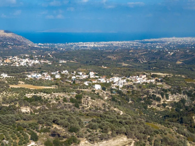
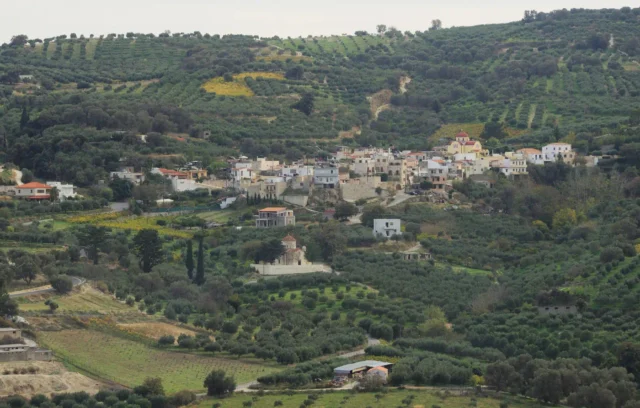
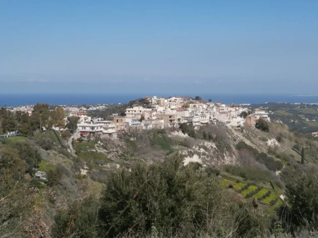
Tylissos enjoys a picturesque setting in a fertile valley on the eastern slopes of Mount Psiloritis, within the Malevizi municipality. Its location offers a harmonious blend of natural beauty and agricultural productivity, with olive groves and vineyards blanketing the surrounding landscape. Situated at an altitude of 200 meters, the village provides its residents with pleasant temperatures and captivating views.
As a large traditional Cretan village, Tylissos boasts a substantial size, currently home to approximately 1,085 permanent residents. Its layout likely reflects centuries of organic growth, characterized by winding streets, whitewashed houses, and a central square that serves as the heart of community life. The village’s dimensions encompass not only its physical footprint but also the sprawling agricultural lands that sustain its inhabitants.
Historical Significance
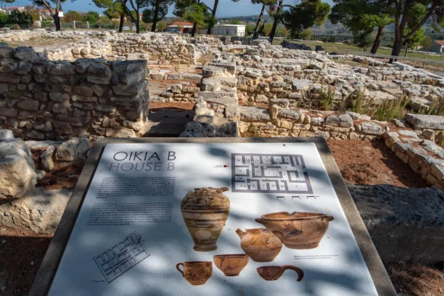
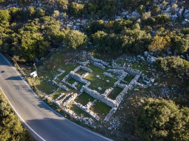
Tylissos’ historical significance is multifaceted. The archaeological site of Tylissos, with its excavated remains of a prosperous Minoan city, offers invaluable insights into Crete’s Bronze Age civilization. The architectural remnants, frescoes, and artifacts unearthed at the site provide tangible evidence of the city’s sophistication and its connections to other Minoan centers like Knossos.
The village’s namesake, the ancient city of Tylissos, is believed to be the only toponym deciphered from the Linear B tablets of Knossos that remains in use today. This linguistic continuity underscores the enduring legacy of the Minoan civilization and its impact on the island’s cultural landscape.
Moreover, Tylissos’ role in the Cretan resistance against Ottoman rule, exemplified by the Battle of Tylissos, solidifies its place in the island’s struggle for independence. The village’s historical churches, such as the church of Agios Nikolaos and the church of Metamorphosis tou Sotiros with its 14th-century frescoes, further enrich its cultural heritage.
Population Data Over the Years
Tylissos has witnessed fluctuations in its population throughout its history.
Year | Population |
|---|---|
1583 | 546 as Telese |
1881 | 583 (536 Christians, 47 Muslims) |
1900 | 775 |
1920 | 932 |
1928 | 1,139 |
1940 | 1,177 |
1951 | 1,322 |
1961 | 1,372 |
1971 | 1,167 |
1981 | 1,230 |
2011 | 933 |
Current Status
Today, Tylissos flourishes as a bustling village with approximately 1,085 permanent residents. Agriculture and livestock farming continue to be the primary economic activities, with the fertile valley providing ample opportunities for cultivation. The village’s rich cultural heritage is evident in its traditional architecture, historical churches, and the nearby archaeological site.
The village’s cultural scene is vibrant, with the Cultural Association of Tylissos, the Youth Association of Tylissos, and the Women’s Association “Diktynna” actively organizing events and promoting local traditions. Sports enthusiasts can enjoy the Tylissos Athletic Club, which participates in the Heraklion Football Association’s first amateur division.
Tylissos stands as a testament to the enduring spirit of Crete, blending its ancient past with its present vitality. Its rich history, agricultural traditions, and vibrant community life make it a captivating destination for those seeking an authentic Cretan experience.
Village Key Points
- Historical References: The village’s name has remained unchanged for over 3,400 years. It is first mentioned in writing in 1271.
- Location: Tylissos is located in the Malevizi municipality, Heraklion regional unit, Crete, Greece. It is situated in a valley on the eastern slopes of Mount Psiloritis, at an altitude of 200 meters.
- Dimensions: The village is considered a large traditional Cretan village, with a population of 933 inhabitants (as of 2011).
- Historical Significance: Tylissos has a long and rich history, dating back to the Minoan era. The archaeological site of Tylissos is a significant attraction, revealing the remains of an important Minoan city. The village also played a strategic role in the Cretan resistance against the Ottomans.
- Population data over the years: Tylissos has witnessed fluctuations in its population throughout its history.
- Current Status: Tylissos is a thriving village with a population of approximately 1,085 permanent residents. The main occupations are agriculture and livestock farming. The village boasts a rich cultural heritage, evident in its traditional architecture, historical churches, and the archaeological site of Tylissos. It also offers various amenities, including a regional medical center, a pharmacy, a Citizens’ Service Centre (KEP), a kindergarten, a primary school, a secondary school, a Second Chance School, a police station, a post office, an OTE branch, an agricultural cooperative, and a Senior Citizen’s Center (KAPI).