


The Geotour Crete Interactive 3D Map: A Tool for Geographical Exploration and Content Integration
The Geotour platform has introduced an Interactive 3D Map, a digital tool developed for the exploration of Crete’s geography. This component utilizes CesiumJS technology to render a three-dimensional model of the island, representing its topography and features. The 3D map allows users to navigate a virtual representation of Crete, offering perspectives on its terrain, including mountains, gorges, and coastlines. Users can manipulate the viewpoint by zooming, tilting, and rotating the camera to examine locations from various angles.
The standalone version of the app can be found at https://www.geotour.gr/vt/3dmap.
The Geotour platform itself is designed to provide insights into the landscapes and heritage of Crete. The primary Geotour website, built on WordPress, serves as a content repository, offering articles, detailed descriptions of sites, historical data, and cultural information. This content covers a range of subjects, including archaeological sites, villages, fortifications, religious locations, and environmental points of interest. Complementing the WordPress site, Geotour incorporates Pano2VR virtual tours, which provide 360-degree panoramic imagery for an on-the-ground perspective of numerous Cretan locales. The new Interactive 3D Map is designed to work in conjunction with these existing components.
Technical Basis and Core Functionality of the 3D Map
The Interactive 3D Map provides a three-dimensional model of Crete, constructed using a Digital Elevation Model (DEM) stored locally and tiled for performance, combined with satellite imagery. This approach aims to offer a realistic depiction of the island’s topography.
Key functions of the 3D map include:
- Geographical Context: It furnishes a visual understanding of Crete’s complex topography, illustrating the scale and relationship of its diverse geographical features. This is intended to provide a more intuitive comprehension of the island’s physical layout compared to traditional two-dimensional maps.
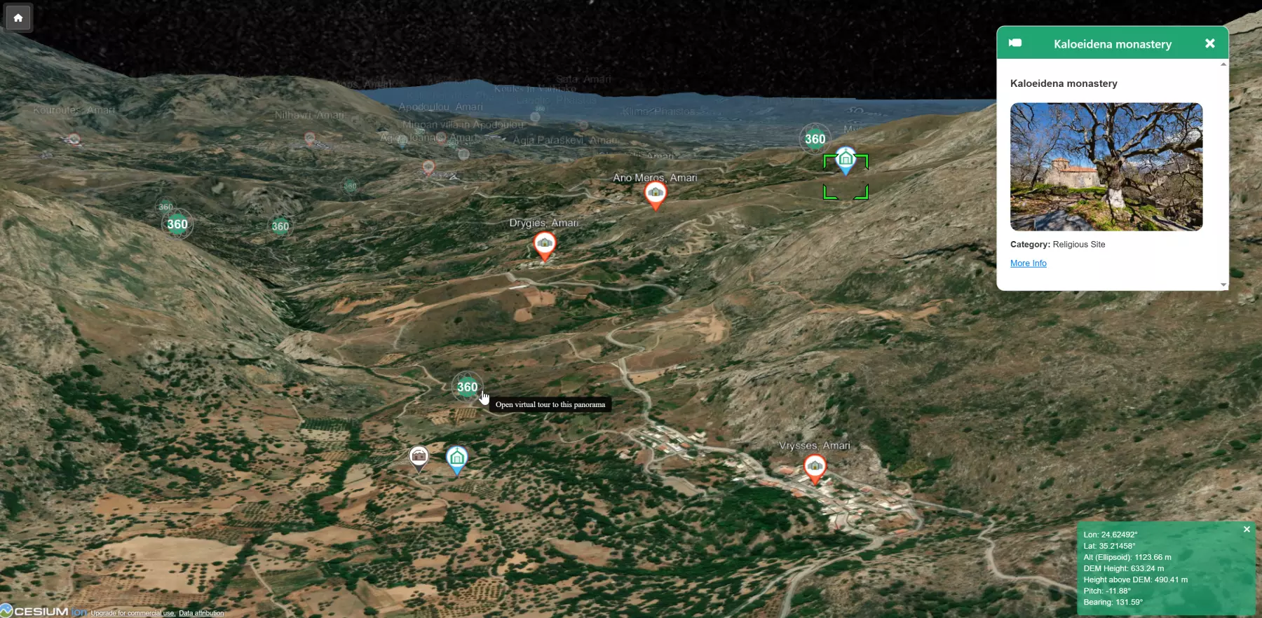
- Point of Interest Visualization: Icons overlaid on the 3D terrain denote locations of interest from Geotour’s listings and other sources. These include archaeological sites, villages, cultural landmarks, and the specific vantage points from which the 360-degree panoramic images in the Pano2VR virtual tour were captured. Clicking a marker typically opens an information box (InfoBox) with details like the place’s name, category, a description, an image, and often a link to the Geotour website for more comprehensive information.
- Spatial Information Resource: The tool can assist users in visualizing spatial relationships between different locations, which can be useful for understanding travel routes or the distribution of sites across the island.
- Contextualization of Portal Content: It enables users to connect the informational content provided on the Geotour WordPress site (such as historical accounts or architectural details) with their corresponding physical locations within the 3D environment.
Additional Features of the 3D Map Application
Beyond basic navigation and POI display, the 3D map application incorporates several specific functionalities:
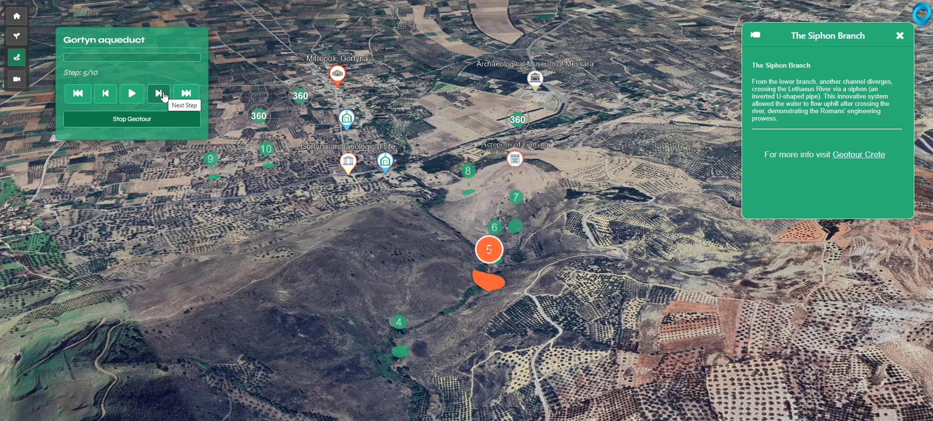
- Guided Geotour Paths: The application features “Geotours,” which are predefined sequences of locations on the map. Selecting a Geotour initiates an automated flight to these locations, with each stop presenting a title and descriptive text to explain its significance within the tour’s narrative. Controls for play/pause, next/previous step, and first/last step allow users to manage their progression through the tour.
Examples of Geotours (for the full list, check the 3D Map)- Ancient Gortyna aqueduct – https://www.geotour.gr/vt/3dmap/?tour=gortyna1
- Kreipe abduction – https://www.geotour.gr/vt/3dmap/?tour=kreipe_abduction_main
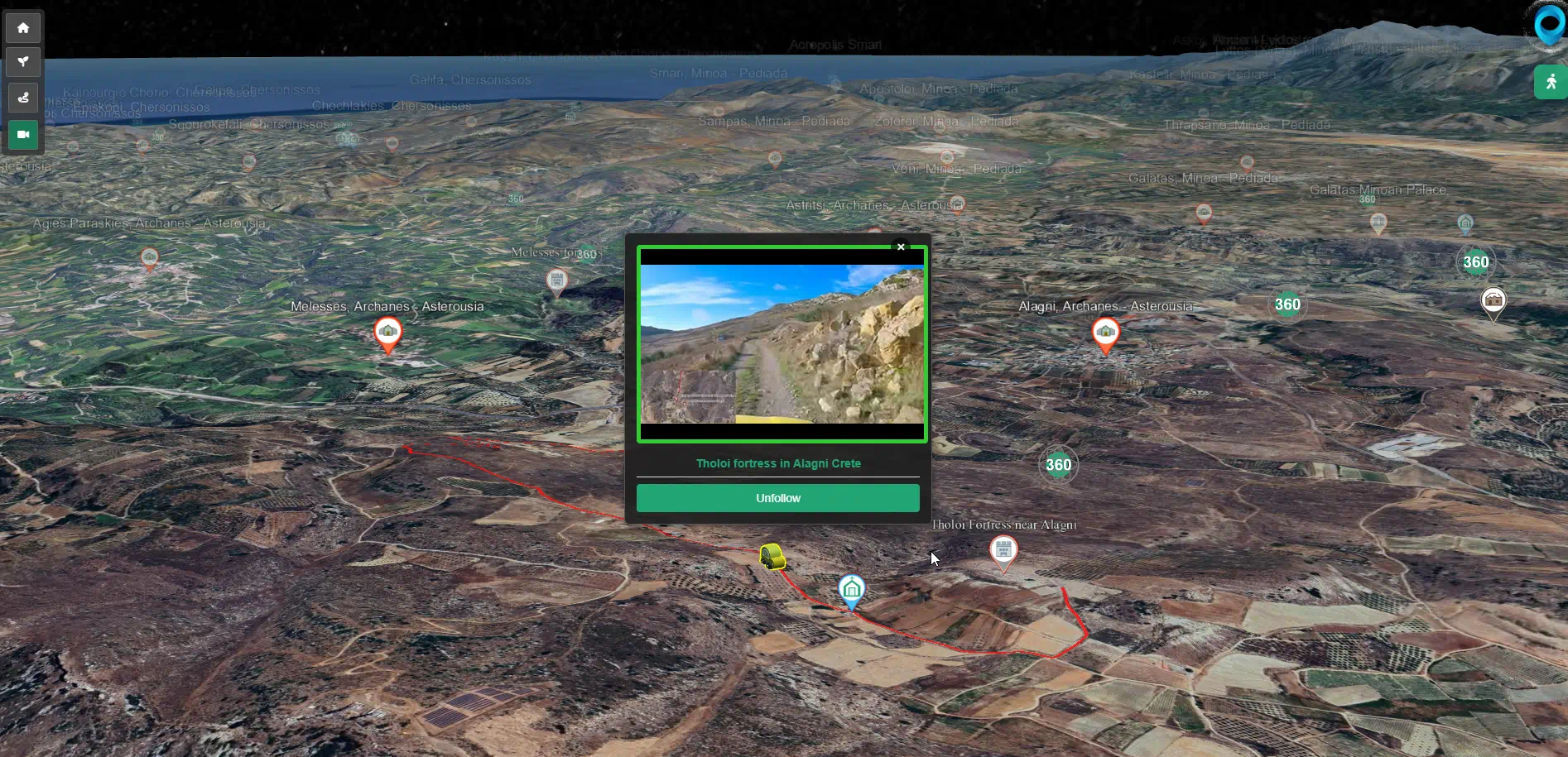
- Synchronized YouTube videos to 3D Video Paths: This feature links YouTube video playback with path visualization on the 3D map. As a video depicting a journey (e.g., a hike or drive) plays in an embedded window, a marker moves along the corresponding route on the 3D map. The synchronization is bidirectional: video playback controls the marker’s map position, and interaction with map-based controls (such as a timeline or points on the path) can navigate the video to corresponding segments.
Examples of Video Paths (for the full list, check the 3D Map)- Paranymfoi to Kofinas Peak and Monasteries of Agios Pavlos and Trion Ierarchon in Asterousia.– https://www.geotour.gr/vt/3dmap/?videopath=asterousia1
- 360 Video – Descending from Samitos mountain – https://www.geotour.gr/vt/3dmap/?videopath=samitos
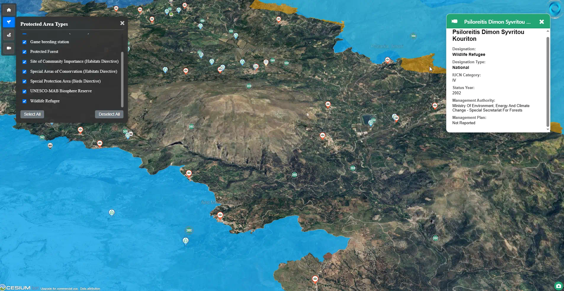
- Protected Areas Layer: The map can display designated protected areas in Crete, such as national parks, wildlife refuges, and Natura 2000 sites, as colored polygons on the 3D terrain. Users can filter these areas by designation type. Clicking on a protected area polygon reveals information such as its official name, designation type, IUCN category, and management details.
- User Interface Elements: The application includes a toolbar for actions like resetting the view, along with notifications for different states. It can also display current camera coordinates (longitude, latitude, altitude) and supports starting the map focused on a specific location via URL parameters.
Interaction Between Platform Components
The Interactive 3D Map is designed to function in concert with the Geotour WordPress site and the Pano2VR virtual tour.
- From Geotour WordPress Site: Content pages on the website may feature direct links allowing users to transition to either the Pano2VR virtual tour for an immersive view or to the Interactive 3D Map to see a location in its broader geographical context.
- From Pano2VR Virtual Tour: Within the 360-degree panoramic environment, interface elements may offer an option to “View on 3D Map.” Selecting this redirects the user to the Interactive 3D Map, with the camera positioned at the geographical coordinates of the viewed panorama, often attempting to align its heading with the user’s perspective in the Pano2VR scene.
- From Interactive 3D Map to Pano2VR: When users are navigating the 3D Map, icons indicate locations for which 360-degree panoramic views are available. The interaction workflow is as follows:
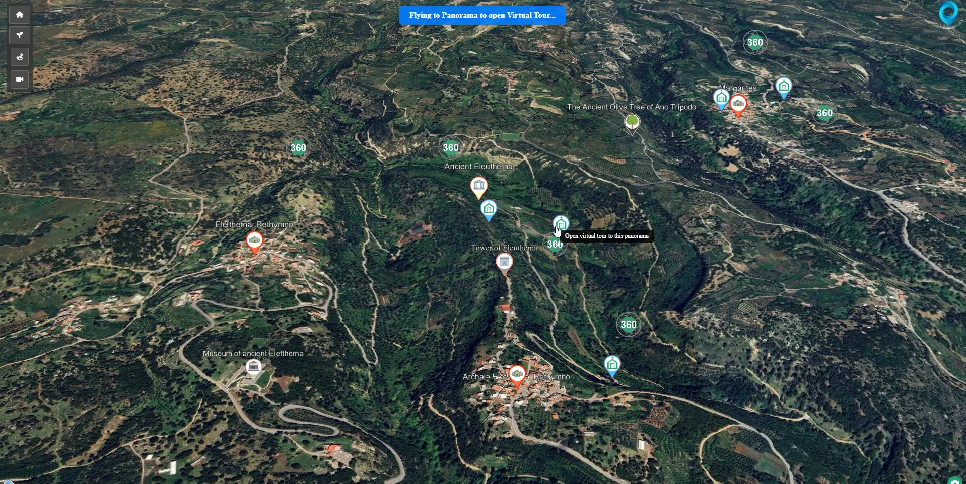
- Hovering the mouse cursor over a panorama icon typically displays a tooltip (e.g., “Open virtual tour to this panorama”).
- Clicking a panorama icon triggers a camera animation within the 3D map. The camera executes a flight to the selected panorama’s coordinates. During this flight, altitude is adjusted (e.g., to 30-50 meters above the panorama’s ground point) and pitch is set (e.g., to -30 degrees), while the pre-click heading is usually maintained. A temporary notification (e.g., “Flying to Panorama to open Virtual Tour…”) may be displayed.
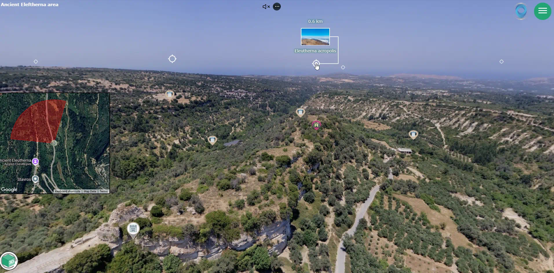
- Upon completion of the camera flight, the browser is automatically redirected to the specific 360-degree scene within the Pano2VR virtual tour. URL parameters are typically appended to the Pano2VR link to carry forward viewing perspective (pan/heading, tilt/pitch, and field of view/zoom), aiming for a consistent orientation between the 3D map view and the initial Pano2VR scene.
User Benefits of the Integrated System
This interconnected system of website, virtual tour, and 3D map is intended to provide users with:
- Improved Spatial Awareness: A more developed understanding of Cretan geography and the spatial relationships between its sites and features.
- Contextualized Information: The ability to more effectively link descriptive and historical data with its precise geographical setting.
- A Cohesive Digital Exploration Method: A more unified and multi-perspective approach to virtually exploring the island of Crete.
The platform aims to present this information and functionality in a manner accessible to a general audience. By highlighting historical, cultural, and natural values through detailed information and varied visual exploration methods, Geotour seeks to encourage a greater appreciation for these locations. The objective is to translate this appreciation into an understanding of their value, thereby contributing to their preservation. In the context of ongoing changes in Crete, presenting the depth and characteristics of these areas through Geotour is intended to support informed consideration regarding the island’s heritage.