


748
listings found
Categories
Active filters:

Hierapytna
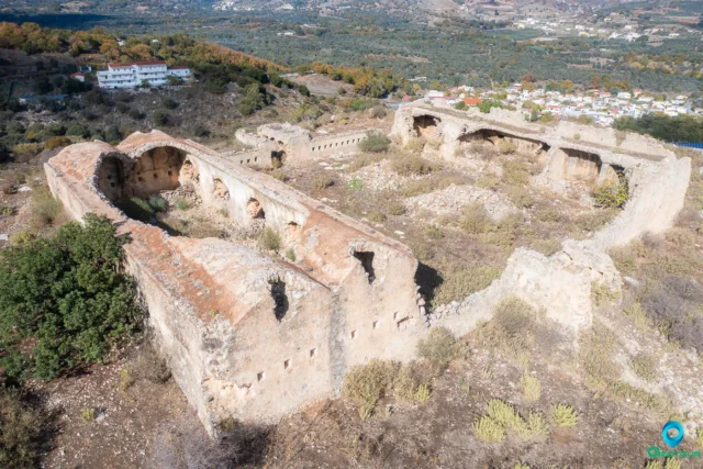
Hierapytna, located on the southern coast of Crete, was founded in the Geometric period (c. 9th century BC). The city was a major hub for trade and commerce in ancient times and played a significant role in the island's political and military affairs. Hierapytna flourished during the Hellenistic and Roman periods. It became part of the Byzantine Empire after the division of the Roman Empire. Following the Arab conquest of Crete in the 9th century, Hierapytna was abandoned. Modern archaeological investigations have revealed a wealth of information about the city, including its city walls, agora, temple, theater, and private houses.
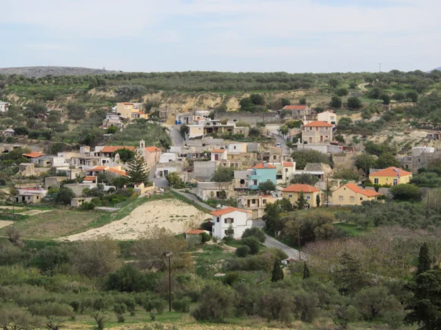
Kato Akria, Gortyna
Kato Akria is a small village in the Ano Akria community, located near Ano Akria and Atsipades. It is the smallest settlement in the municipal district, with a population of […]
Rouma abandoned village near Alagni
Rouma, a deserted village east of Alagni in Crete, takes its name from the Cretan word for "river stream." The village, formerly abundant in oak and pine trees, was abandoned after a plague outbreak. Survivors relocated to Alagni. Despite its abandonment, Rouma is remembered for the church of Panagia tou Roumatou (Virgin Mary of Rouma), a landmark that remains historically and religiously significant. A 1630 census recognized Rouma as a separate village. The restored church of Panagia tou Roumatou is a reminder of Rouma's past, with excavated sacred vessels further highlighting its history.
Karaoula Wine Press near Alagni
A 14th-century, likely pre-Venetian, wine press near Alagni, Crete, at an altitude of 520 meters. The facility illustrates a traditional two-phase winemaking process. Grapes were first crushed by foot in a large press (5.5m×6m) lined with kourasani, with the must collected in an underground tank. The remaining pomace was then pressed using a Galeagra. The stone base of this second press and collection receptacles survive, offering insight into Cretan viticulture and land use.
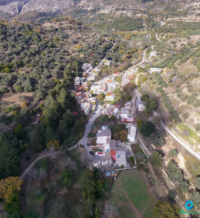
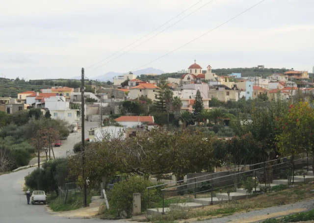
Goulediana, Rethymno
Goulediana, a small mountain village nestled in the Rethymno regional unit of Crete, Greece, presents a captivating blend of natural beauty and historical intrigue. Perched at an altitude of 540 meters in a small valley, this quaint village is located 18 kilometers from the city of Rethymno.
Though absent from Venetian censuses, Goulediana is believed to have existed as a metochi, a dependency of a monastery. The village's history stretches back to the Archaic period, as evidenced by the Onithi archaeological site southeast of the village. This site features remnants of a fortified acropolis, houses, and a monumental fountain dating to the 7th-6th century BC. Further historical significance is found in the Early Christian basilica at Kera Onithi, dating to the 5th century AD. Goulediana also boasts several churches of note, including the 1787 Agia Kyriaki with its sanctuary housed within a cave, Agia Varvara, and the Genethlio tis Theotokou. The wider Goulediana area encompasses churches such as the Panagia Kera, Zoodochos Pigi, Koimisis tis Theotokou, Agios Antonios (cave), and Metamorphosis tou Sotira. Despite its rich historical tapestry, Goulediana has experienced a declining population in recent years.
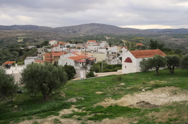
Stamnoi, Chersonissos
With a history dating back to antiquity with notable features the Church of the Savior Christ and "The Tower" a Venetian-era, two-story building.
Kato Vatheia, Chersonissos
A village in the Vatheianos River valley, this settlement dates back to 1271 and features the Church of Agia Aikaterini.
Epano Vatheia, Chersonissos
Epano Vatheia is a settlement located in the Heraklion regional unit on the island of Crete, Greece. It belongs to the Municipality of Chersonissos
Galipe, Chersonissos
Galipe, a historic village in Heraklion, Crete, sits at 280 meters above sea level. First documented in 1299, Galipe's history reflects Venetian and Ottoman influences. The 16th-century Church of the Assumption of the Virgin Mary, featuring a Venetian tomb monument, and the 15th-century Old Church of Agios Nikolaos are key landmarks. A central stone fountain adds to the village's charm. Galipe's economy centers on agriculture, particularly grapes and olives. The village's population has fluctuated over time, reflecting its dynamic history.
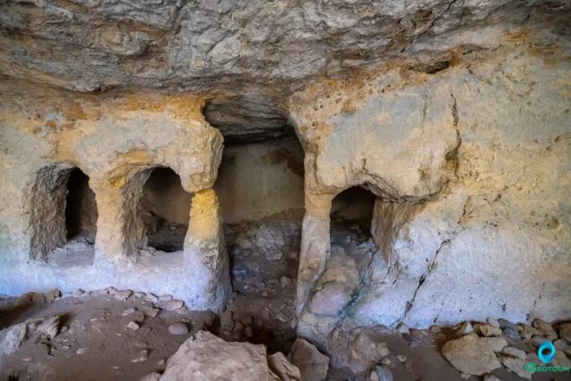
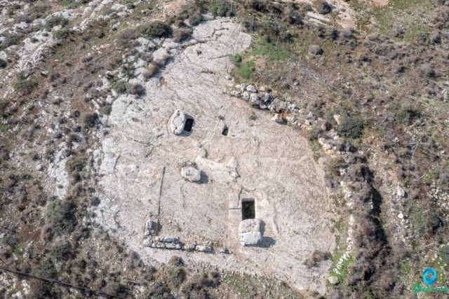
Siderospilia near Roufas
Siderospilia, meaning "Iron Caves," is a complex of three interconnected chambers carved into limestone bedrock near Roufas, Crete. Its purpose is debated, with theories ranging from blacksmith workshop to Roman-era burial site. Chamber 1 features a broken supporting column, roof opening, and stone bench. Chamber 2 is larger, with niches for burials. Chamber 3 resembles an early Christian church, with a dividing wall and door. Local legends link the cave to blacksmiths, ghosts, and eerie sounds. Some believe it was a dwelling before becoming a necropolis. The cave's location near a stream and possible ancient structures adds to its significance. Siderospilia is accessible but lacks official signage.
The Koules of Koxare
The Koules of Koxare is an Ottoman-era fortress located near Koxare village at the entrance of Kourtaliotiko Gorge in Rethymno Prefecture, Crete. Built between 1866 and 1869, it was part of a network of fortifications designed to control movement and quell rebellions on the island. The Koules is characterized by a large internal courtyard, thick stone walls, and remnants of arched structures. Partially destroyed in 1896 during the Cretan revolution, it stands as a testament to the island's struggle for freedom from Ottoman rule. Despite its deteriorated state, the Koxare Koules remains an important historical landmark with potential for preservation and tourism development.
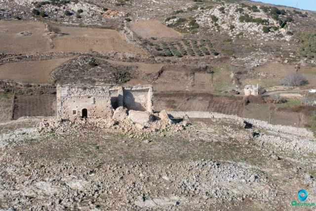
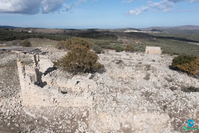
Tholoi Fortress near Alagni
The Tholoi Fortress, near Alagni, Crete, dates to the 16th-17th century, reflecting Venetian and Ottoman periods. Situated on a hilltop, it served as a strategic point for surveillance and defense. Its design shows Venetian villa influences, with local stone construction. The fortress, now in ruins, experienced damage, including from the 2021 Arkalochori earthquake, but the outer wall remains. Nearby, the 15th-16th century Church of Agioi Apostoloi, bearing the Corner family crest, suggests a connection to the fortress, possibly as a spiritual center. The fortress, with dimensions of 15 by 9 meters, played a role in Venetian-Ottoman conflicts and potentially as a Turkish "koules" during the 1866-1869 Cretan Revolution.
Sata, Amari
Sata is a settlement located in the Rethymno regional unit on the island of Crete, Greece. It belongs to the Municipality of Amari
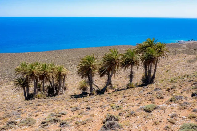
The Palm Forest of Agios Nikitas
The palm forest of Agios Nikitas in Crete is the only place on the island where the Cretan palm grows at a distance from the sea.
Mardati, Agios Nikolaos
Mardati is a settlement located in the Lasithi regional unit on the island of Crete, Greece. It belongs to the Municipality of Agios Nikolaos
Voulismeni, Agios Nikolaos
Voulismeni is a settlement located in the Lasithi regional unit on the island of Crete, Greece. It belongs to the Municipality of Agios Nikolaos
Vrachasi, Agios Nikolaos
Vrachasi is a settlement located in the Lasithi regional unit on the island of Crete, Greece. It belongs to the Municipality of Agios Nikolaos
Dreros, ancient city
Dreros, also known as Driros, is an archaeological site near Neapoli in Crete, significant for its post-Minoan remains from the early Archaic Period. Flourishing from the 8th to 6th centuries BC, Dreros was an important center of trade and culture, known for its harbor, temples, bronze working, and pottery. The city, built on two hills, features a sanctuary dedicated to Apollo Delphinios, where 8th century BC bronze statuettes of Apollo, Artemis, and Leto were discovered. A large, open cistern, possibly used for ritual purposes, was found in the agora, the city's public gathering space. Inscriptions reveal a board of officials called the 'Twenty of the Polis' and the division of the people into 'phylai' or tribes. The site includes one of the earliest known examples of a Greek temple, dedicated to Apollo Delphinios. Dreros declined in importance after the 6th century BC and was eventually abandoned.
Kato Metochi, Lasithi plateau
Kato Metochion is a settlement located in the Lasithi regional unit on the island of Crete, Greece. It belongs to the Municipality of Lasithi plateau
Pinakiano, Lasithi plateau
Pinakiano is a settlement located in the Lasithi regional unit on the island of Crete, Greece. It belongs to the Municipality of Lasithi plateau