


11
listings found
Categories
Active filters:
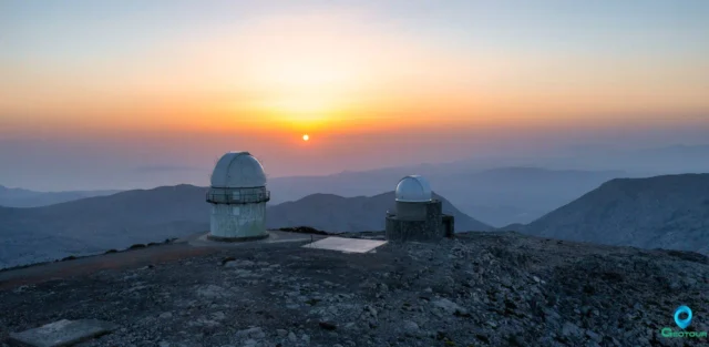
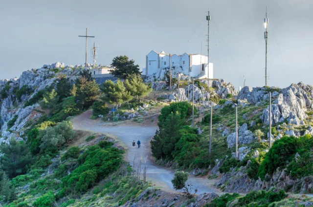
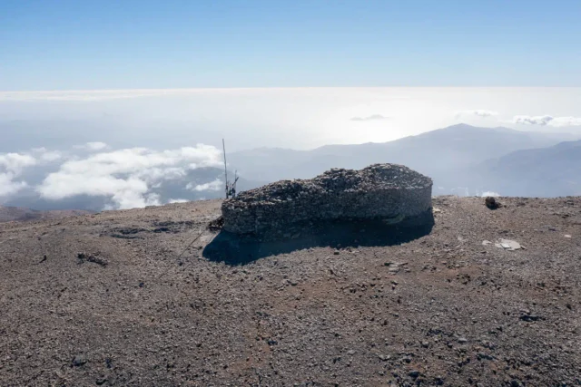
The Summit of Skinakas Skinakas Observatory
At 1,750m on Psiloritis, a UNESCO Global Geopark, the peak offers panoramic views of Crete. The site hosts the Skinakas Observatory, founded in 1984 by the University of Crete, FORTH, and Max Planck Institute. It features a 1.3m telescope and the new 1.0m "200+" telescope. Powered by a photovoltaic park since 2000, it has produced numerous scientific publications. The observatory hosts public "Open Nights" and maintains strong ties with the nearby village of Anogeia.
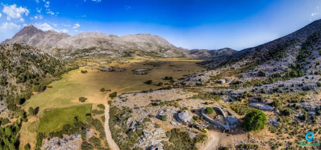
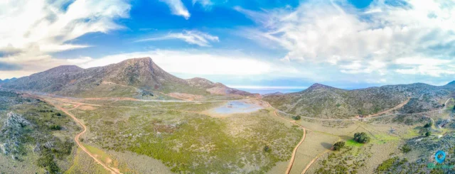
Nida mountain plateau
The Nida Plateau is a large polje at an average altitude of 1,400 meters in central Crete’s Psiloritis massif, a key part of the Psiloritis UNESCO Global Geopark. Its creation resulted from the Idaion Fault and karstification processes. The plateau is a critical water source for the region, with water vanishing into sinkholes. It is home to the Ideon Andron, the mythological cave where Zeus was raised, which was a major religious sanctuary for 3,000 years. The local culture is defined by its stone shepherd's huts (mitata).
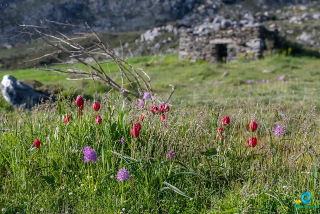
The Gious Kampos Plateau
Gious Kampos is an ecologically important high-altitude plateau (750m avg. elevation) in the Amari Valley administrative area, Rethymno, Crete, situated on the northwest side of Mount Kentros. Its geology, combining clay rocks with limestone outcrops, fosters unique hydrology and fertile soil. The name potentially derives from "Plain of Eos" (dawn) or "Plain of the Goats." Designated a Natura 2000 site, it's renowned for exceptional biodiversity, serving as the primary habitat for the protected endemic Cretan red tulip, Tulipa doerfleri. The plateau also hosts a remarkable density and variety of orchids, including Orchis italica and Neotinea tridentata. Historically and currently vital for agriculture (cereals, vegetables, fruit trees) and pastoralism for surrounding villages like Spili and Kissos.
Strouboulas Massif
Located in Crete's Malevizi Province near Tylissos and visible from Heraklion, this mountain range features a prominent peak (798m) noted for its conical shape. Historically called "Stroggylo," Venetians named it after Stromboli. The range includes the Strouboulas plateau, south of the ridge, formed on limestone ("Tripoli" zone), leading to karstic features like the Tafkos tou Palmetis chasm, linked to Ottoman-era resistance. Vegetation is sparse, dominated by Kermes Oak due to overgrazing. A seasonal lake forms on the plateau, its water often reddish from soil runoff. Historical significance includes Minoan foothill settlements, the Timios Stavros chapel (Holy Cross) on the summit mentioned in 1415, possibly on an older site, and the Agios Georgios chapel ruins below, once a monastery dependency. Access to the peak involves a path from the plateau offering panoramic views.
Giouchtas mountain
Giouchtas Mountain, a prominent 811-meter peak south of Heraklion, Crete, features significant Minoan peak sanctuaries, including Psili Korfi and Anemospilia, dating to the 2nd millennium BCE. Anemospilia's findings suggest possible human sacrifice. Associated with Zeus, it hosts the Afendi Christos church (1443). The mountain supports diverse flora (360+ species) and fauna (150+ bird species, including griffon vultures), within maquis and phrygana landscapes, and reforestation areas. Part of the Natura 2000 network, it faces pressures from urbanization and tourism. Hiking trails lead to viewpoints and historical sites, offering insights into Minoan civilization and natural biodiversity.
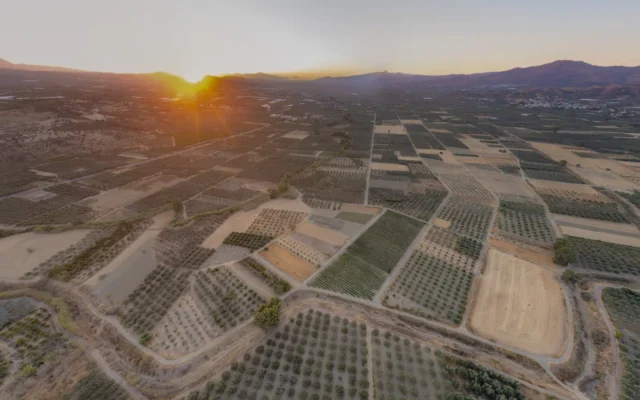
Messara plain
The largest plain in Crete is situated in the south of Heraklion, between the Psiloritis and Asterousia mountains, with a 55 km coastline on the Libyan Sea. Its fertile land, irrigated by the Geropotamos River, is ideal for cultivating olives and grapes. A center of civilization since the Neolithic period, it contains significant archaeological sites, including the Minoan palace of Phaistos, the royal villa of Agia Triada, and the port of Kommos. Gortyn later became the Roman capital of Crete.
Metochi of Kamilari
Metochi, Crete, is known as the alleged birthplace of Epimenides, an ancient sage. The village holds historical significance with its agricultural roots and traditional architecture. Plutarch's writings link Epimenides to Metochi, sparking interest in his legendary life, including his famed 57-year slumber. The area features olive groves and ancient ruins, enhancing its historical allure. Beyond its Epimenides connection, Metochi offers Cretan cuisine and access to the Mesara Plain's natural beauty.
Timios Stavros peak, Psiloritis mountain
At 2456 meters, Timios Stavros is the highest summit of Crete's Psiloritis mountain range, offering 360-degree views of the island, Aegean, and Libyan Seas. It is accessible via the E4 path from Nida Plateau or the stone-paved "Strata tou Psiloriti" trail. The peak features a dry-stone chapel. The range includes other notable peaks such as Agathias, the second-highest; the pyramidal Stolistra; and Skinakas, which is the site of a well known observatory.
Kofinas peak
Kofinas peak sanctuary in Crete offers insights into Minoan religious practices, societal structures, and the relationship between humans and the natural world.
Lithino Cape, Kefali peak
Lithino Cape, the southernmost point of Crete, features a rugged landscape with cliffs and remnants of WWII German fortifications. The cape's strategic location, offering a commanding view of the southern coastline, led the Germans to construct these fortifications to defend against potential invasion. Mount Kefali, situated on the cape, rises to an elevation of 388 meters and offers stunning views of the coastline, Gavdos, and the Asterousia Mountains. Atop Kefali Peak stands the small stone church of Timios Stavros, a testament to the site's enduring importance as a place of worship and refuge. The ruins of pillboxes built by the Germans during the Second World War are a stark reminder of the cape’s strategic value.

Katharo plateau
Situated in the Dikti mountain range of Lasithi, Crete, 26km from Agios Nikolaos, this plateau rests at 1150m altitude. Its waters flow via the Havgas Gorge to the Lasithi Plateau. Human activity dates back to the Minoan era. Ownership was historically disputed between Lasithi and Kritsa residents, eventually awarded to Kritsa after legal battles documented in Greek and Turkish archives; a legend involves a Turkish judge and the site "Kadi's Pit". Today, it's primarily used for cultivating potatoes, apples, and vineyards by Kritsa residents who lease the land. Access is via paved road from Kritsa through an oak forest, or dirt roads from Lasithi Plateau and Malles Ierapetras; the E4 trail also passes through. Points of interest include the Avdeliakos settlement, the Chapel of Afentis Christos, and Kadi's Pit. The area offers cool summer temperatures, hiking opportunities, and hosts the annual Shepherd's Festival after August 15th.