A Minoan Administrative and Economic Center in Eastern Crete
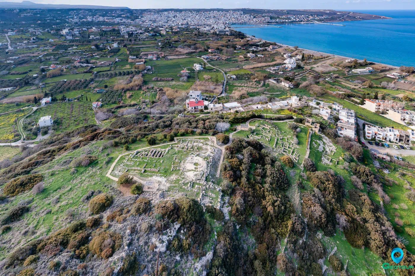
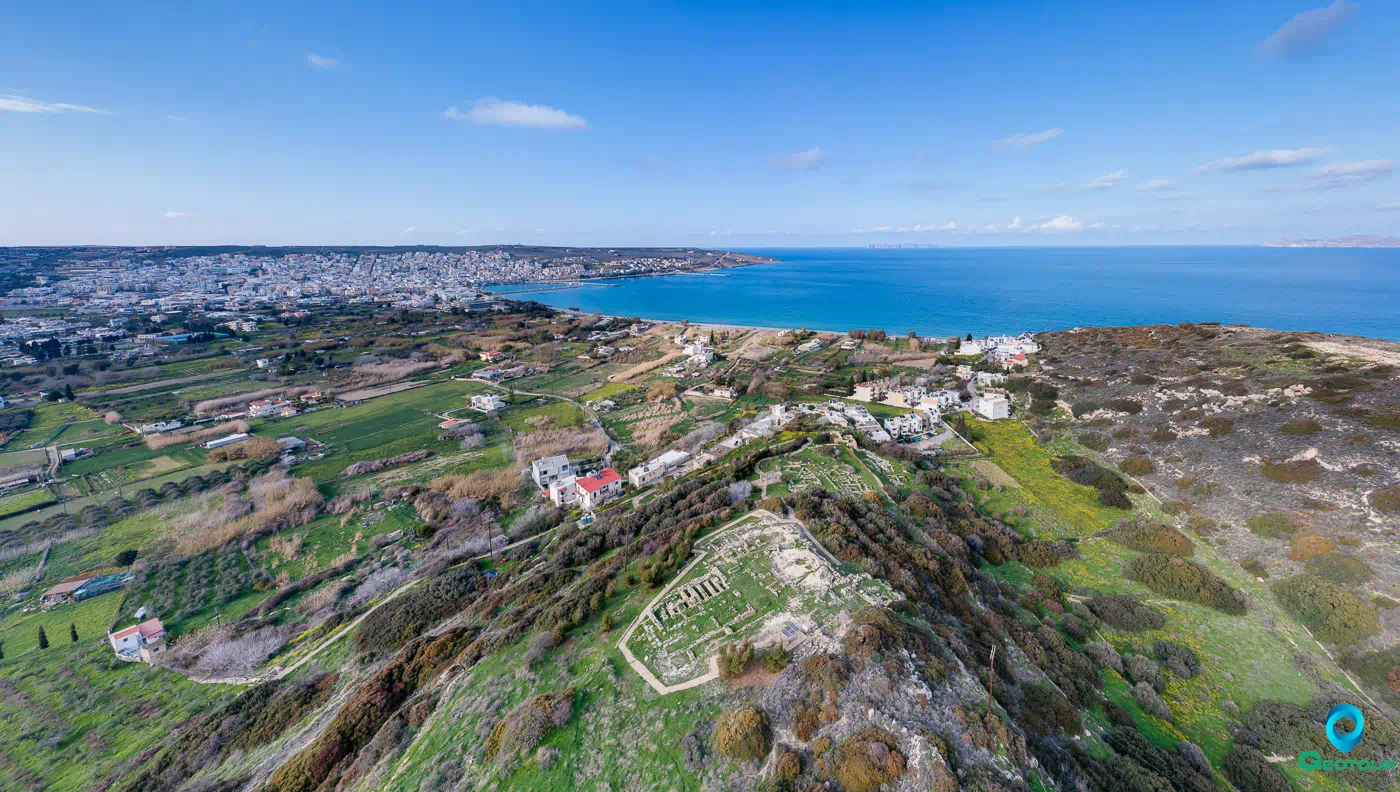
Petras is a significant Minoan archaeological site located near Siteia in eastern Crete, Greece. Excavations, primarily led by Metaxia Tsipopoulou since 1985, have revealed a long and complex history of occupation, spanning from the Final Neolithic (FN) period through the Byzantine era. The site’s importance stems from its well-preserved Minoan settlement, featuring a small palace, associated urban structures, industrial areas, and cemeteries. Petras provides valuable insights into Minoan civilization, particularly in eastern Crete, and its interactions with other regions.
Historical Overview and Occupation Periods
Petras boasts a continuous occupation history, with evidence of human activity from various periods:
- Final Neolithic (FN) – Early Minoan (EM) I (ca. 4000-3000 BCE): The earliest settlement was located on Kephala Hill (Hill II), east of the later palace. This settlement was well-organized and showed evidence of copper working and obsidian processing, with possible connections to the southern Dodecanese (Nowicki 2002; Tsipopoulou 2012).
- Early Minoan (EM) II: The first settlement on the hill where the palace was later built dates to this period. A complete house with two rooms and a forecourt was found (Tsipopoulou 2012).
- Prepalatial Period (EM III – MM IA): Larger buildings were constructed on the palace hill, indicating the emergence of elites (Minoan Crete Website).
- Protopalatial Period (MM IB – MM IIB): The first palace was constructed in MM IIA, slightly later than the larger palaces in central Crete. This period saw increasing administrative complexity, evidenced by a hieroglyphic archive. The first palace was destroyed by fire, possibly after an earthquake, around 1700 BCE (MM IIB) (Buell 2015; Tsipopoulou 2012; Minoan Crete Website).
- Neopalatial Period (MM III – LM IB): The palace was rebuilt and expanded, with the addition of large north magazines. This period represents the height of Petras’s influence. The second palace was destroyed by fire in LM IB (Tsipopoulou 2012; Minoan Crete Website).
- Postpalatial Period (LM IIIA–IIIC): There is evidence of limited reoccupation of the palace area and slopes (Minoan Crete Website).
- Byzantine Period: The palace hill was used as a cemetery in the 12th century CE (Tsipopoulou 2012).
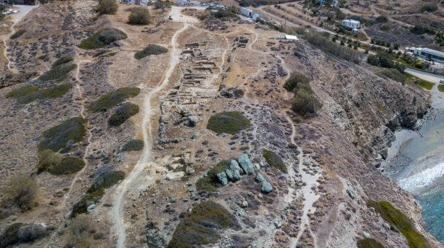
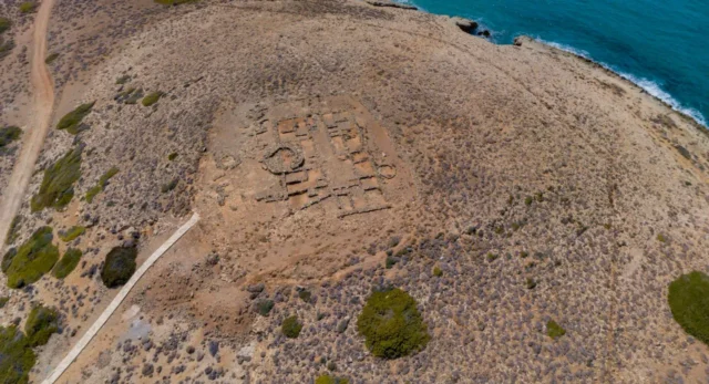
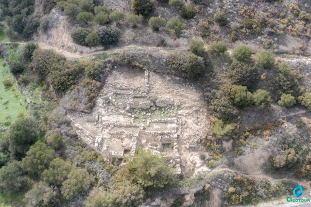
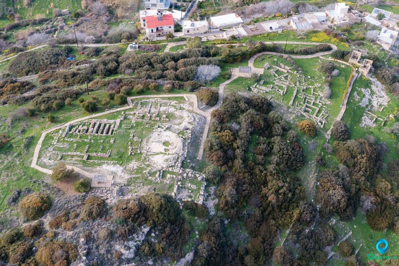
The Palace: Architecture and Administration
The palace at Petras, though smaller than those at Knossos, Phaistos, or Malia, exhibits characteristic Minoan palatial features (Tsipopoulou 2012).
Key Architectural Elements:
- Central Court: A defining feature, albeit smaller than at other palaces, with a plaster floor and drainage system (Minoan Crete Website).
- Magazines: Extensive storage areas, particularly the North Magazines added in the Neopalatial period, indicate Petras’s role in the collection and redistribution of agricultural produce (Minoan Crete Website; Tsipopoulou 2012).
- Ashlar Masonry: Used in construction, showcasing skilled craftsmanship (Tsipopoulou 2012).
- Pier-and-Door Partitions: Used for controlling access and light within the palace (Minoan Crete Website).
- Monumentality and Formality (Buell 2015).
- Hieroglyphic Archive: The best-preserved Minoan hieroglyphic archive, found in the west wing, demonstrating administrative activity. It contained clay tablets, sealings, and other writing implements (Minoan Crete Website; Tsipopoulou 2012).
- Linear A Inscriptions: A few Linear A inscriptions were also found, although not as numerous as the hieroglyphic ones (Minoan Crete Website).
- North-south orientation (Buell 2015).
- Rapid construction (Buell 2015).
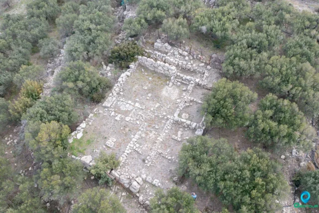
The Settlement: Urban Context and Economy
The palace was the center of a larger urban settlement, extending across the plateau and surrounding hills (Tsipopoulou 2012).
- Houses: Excavations have revealed several houses, including the well-preserved Neopalatial Houses I.1 and II.1. These houses provide insights into domestic life, craft production (including weaving and dyeing), and the social hierarchy (Minoan Crete Website).
- Industrial Areas: Evidence for various industries has been found, including pottery production, purple dye production (dating back to EM II-III), and textile production (Nowicki 2002; Minoan Crete Website).
- Fortification Walls: Both Protopalatial and LM III fortification walls have been discovered, indicating periods of concern for defense (Tsipopoulou 2012).
- Pottery Production: The Petras-Piskokefalo Group workshop made octopus-style pottery (Koh and Clinton, 2015).
- Territorial Organization: Settlement was part of a larger territorial organization (Nowicki, 2018).
Site: Key Points
- Location: Near Siteia, eastern Crete, overlooking the sea from a small plateau.
- Long Occupation History: From the Final Neolithic to the Byzantine period.
- Minoan Palace: A small but well-organized palace with a central court, magazines, and administrative areas.
- Hieroglyphic Archive: The best-preserved Minoan hieroglyphic archive, indicating administrative activity.
- Urban Settlement: The palace was part of a larger settlement with houses, workshops, and fortifications.
- Economic Activities: Evidence for agriculture, pottery production, purple dye production, and textile production.
- Strategic Location: Situated near the coast, with access to harbors and fertile land.
- Destruction: The first palace destroyed in MMIIB. The second one at LMIB.
Significance and Current Status
Petras is a crucial site for understanding Minoan civilization, particularly in eastern Crete. It provides valuable information on:
- Regional Administration: Petras served as a local administrative center, controlling the surrounding area and its resources.
- Economic Networks: The site’s evidence for trade and craft production illuminates Minoan economic practices and interactions.
- Social Organization: The palace, houses, and cemeteries offer insights into Minoan social hierarchy and daily life.
- Transition Periods: The settlements shows how society and politics changed between periods (Nowicki, 2018).
Excavations and research at Petras are ongoing, led by Metaxia Tsipopoulou. The site is open to the public, allowing visitors to explore the remains of the palace and settlement.
References
- Buell, D. M. (2015). Minoan Cityscapes: Urban Planning in Neopalatial Crete. Presses universitaires de Louvain.
- Koh, A. J., & Clinton, M. G. (2015). Contextualizing the Late Minoan Tombs of the Western Siteia Mountains. Journal of Eastern Mediterranean Archaeology and Heritage Studies, 3(4), 233-257.
- Nowicki, K. (2002). The End of the Neolithic in Crete. Aegeum, 23, 153-168.
- Nowicki, K. (2018). Settlement patterns and social organisation in Crete during the Final Neolithic and the beginning of the Bronze Age (ca. 3700-3000 BC). Oxbow Books.
- Tsipopoulou, M. (2012). 25 years of excavations and studies at Petras, Siteia. In Petras, Siteia: 25 years of excavations and studies. Monographs of the Danish Institute at Athens, Volume 16. (pp. 13-436). The Danish Institute at Athens and Aarhus University Press.
- Wikipedia contributors. (2023, October 25). Petras. In Wikipedia, The Free Encyclopedia. Retrieved November 7, 2023, from https://en.wikipedia.org/w/index.php?title=Petras&oldid=1181887140
- Minoan Crete. (n.d.). Petras. Retrieved November 09, 2023, from https://minoancrete.com/petras/