Μυρσίνη (Myrsini) is a village in the municipality of Sitia, in Lasithi, eastern Crete. It is built at an altitude of 330 meters, on the road that connects Sitia with Agios Nikolaos, 25 kilometers from Sitia.
The community of Myrsini was established in 1928.
Historical data
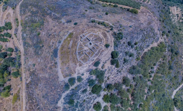
In the position of Galana Charakia, a Minoan circular tomb with over 60 burials and pottery of the Proto-Minoan and Meso-Minoan era, larnaxes and pithoi were discovered. In the position of Chalinomouri, tombs of the Late Minoan years were discovered in which pottery, weapons and utensils were found. In the position of Kastellos or Lenika there is an ancient city and in the position of Avgo a fortress of the Late Minoan era. In the hill of Asprospilia, a cemetery of the Late Minoan era with room-tombs was excavated in 1959.
The village is not mentioned in the Venetian censuses. R. Faure suggested that the toponym Cathia mentioned by Francesco Bazilicata in a map of 1629 is Myrsini. The oldest mention of the settlement is the Egyptian census of 1834, where it is mentioned as Metochia, with 22 Christian families and 2 Turkish ones. In the census of 1881 it is mentioned as Metochia Tourlotis with 440 Christian inhabitants and 7 Turks. In 1920 the name of the settlement changed to Myrsini, due to the many myrtle trees that grow in the area. In 1928 it was in the community of Tourloti but in 1940 it had its own community.
Tower of Kornaros
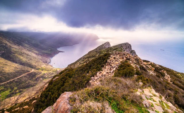
Northeast of the village, near the sea, there is a medieval tower known as the Tower of Kornaros or the Tower of Agios Antonios, from the nearby church dedicated to Saint Anthony. In the northern wall inside the church there is an inscription “Vicenzo Cornaros 1677”, perhaps a descendant of the family of the homonymous poet. In the area there was a settlement during the Venetian and Ottoman rule. The tower was rebuilt during the Venetian rule, possibly as a tower house. The total height of the tower together with the battlements reaches 12 m and the perimeter of its base, 22 m. It has two entrances on the west side, one for the ground floor and one for the upper floors. The Tower was partially destroyed during the revolution of 1897, when Myrsiniotes tried to demolish the tower with dynamite, so that it would not be used by the Turks. The tower suffered some cracks and was not used again. A part of it collapsed during heavy rain in 1918. The tower was restored by the Sitia Development Organization in 1999 and became accessible in 2007.
Population data
Population trend according to censuses:
Year |
Population |
Notes |
|---|---|---|
1583 |
||
1881 |
447 |
440 Christians, 7 Muslims, as Metochia Tourlotis |
1900 |
358 |
as Metochia Tourlotis |
1920 |
366 |
|
1928 |
339 |
|
1940 |
402 |
|
1951 |
343 |
|
1961 |
317 |
|
1971 |
277 |
|
1981 |
261 |
|
1991 |
196 |
|
2001 |
193 |
|
2011 |
147 |
|
2021 |
162 |
Economic data
The economy of Myrsini is based today on agricultural production, with the main products being olive oil and grapes. Also, the inhabitants of the village work in the hotels of Mochlos. There are two taverns operating in the village. In 1928 the agricultural credit cooperative of Myrsini “Progress” was founded in the village and in 1933 the Myrsini winery cooperative “Agrilos”, which in 1961 was converted into an olive mill, but today its operation has stopped.
Settlement: Key Points
- Historical References: The village is not mentioned in Venetian censuses, first reference as Metochia in 1834 Egyptian census.
- Location: Located in eastern Crete, on the road connecting Sitia and Agios Nikolaos.
- Historical Significance: The name changed to Myrsini in 1920 due to the abundance of myrtle trees.
- Population Data: See table above.
- Current Status: A small village in the municipality of Sitia, known for its agricultural products.
References
- Wikipedia
- prosym.g