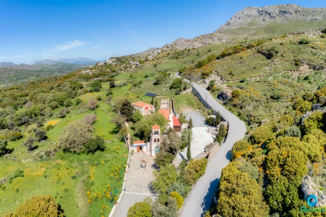
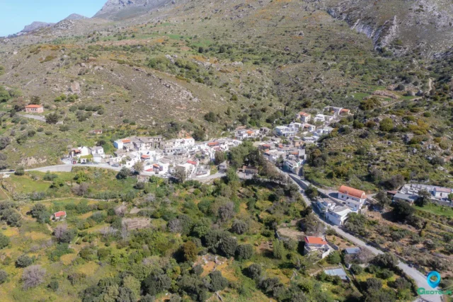
Kentrochori (Κεντροχώρι), officially Kentrochorion (Κεντροχώριον), is a village within the Municipality of Agios Vasileiou in the Regional Unit of Rethymno, Crete. Until 1933, it was known as Doumaergio (Δουμαεργιό) and earlier as Vuidomagergio (Βουιδομαγεργειό). The village is located 37.5 kilometers from the city of Rethymno, situated at an altitude of 530 meters on the southern foothills of Mount Kentros.
Name and Local Tradition
The village’s name has seen significant variation throughout its history. Its earliest known names were Vudomaierio or Vuidhomagiergio. This was later altered to Doumaergio, which remained in use until the early 20th century. In 1933, it was officially renamed Kedrochori (Κεδροχώρι), which was corrected in 1940 to its current name, Kentrochori.
A local legend attempts to explain the origin of the old name, Vuidomagergio. According to this tradition, during the Byzantine era, a noblewoman named Maria owned a vast expanse of land from Mount Kentros to the Libyan Sea. To cultivate this land, she employed teamsters and oxen. The settlement that formed, housing the workers and their animals, was named Vuidomagergio, a combination of the Greek words for oxen (vóia) and cookhouses (mageireiá), where food was prepared for the laborers. The legend also credits Maria with building the nearby Holy Spirit (Agios Pnevmatos) Monastery, where she later became a nun.
Historical Information
The earliest written record of the settlement appears in a 1301 notarial contract from Handakas (Heraklion), where it is listed as Vudomaierio. Subsequent historical documents and censuses record the village under various names.
In the Venetian period, Francesco Barozzi mentioned it in 1577 as Vuidhomagiergio in the province of Agios Vasileiou. The 1583 Venetian census by Kastrofylakas recorded it as Vuidhomargiergio with a population of 60. In 1630, the cartographer Vasilikata listed it as Vuidho Magiero. During the Ottoman era, the 1659 census recorded it as Vidu Mayeryo, with 20 houses. In the same year, the village was documented as having significant agricultural properties, including fields, 146 olive trees, and vineyards. Documents from the Heraklion Kadi court dated 15/2/1659 show that the timar (fief) of Voudomagergeio was granted to Mehmet Bey, the head of the Chania Regiment, for his services to the Sultan.
In the Egyptian census of 1834, it was listed as Dumaghergo. The 1881 census shows the village, then named Doumaergio, as part of the Municipality of Agiou Pnevmatos, with a purely Christian population of 195. By 1900, the population had grown to 246.
Administrative History
In 1925, the settlement of Doumaergio was officially attached to the community of Ardaktos. By 1930, it was joined with the nearby settlement of Platanes to form the new community of Kentrochori, and in 1931 it was designated as the seat of this community. Following the Kapodistrias administrative reform plan, Kentrochori was incorporated into the Municipality of Lampi. Under the current Kallikratis and Kleisthenis I plans, it is the seat of the Community of Kentrochori (which also includes Platanes) within the Municipal Unit of Lampi of the Municipality of Agios Vasileiou.
Surrounding Area
Kentrochori is closely associated with the nearby settlement of Platanes, which is also found in Venetian census records from the 16th and 17th centuries.
The village lies at the foot of Mount Kentros, which is traditionally said to have 101 springs. The 17th-century poet Marinos Tzane Bounialis, in his work The Cretan War, wrote of the mountain: “Kentros, which had a hundred springs around it, happened to be called Paradise by name…” The mountain’s numerous water sources create waterfalls along its slopes during the winter and spring.
A location north of Platanes, known as Apano Platanes (Απάνω Πλατανές), preserves remnants of the ancient forests of Crete, including large holm oaks (prinaria) with trunk perimeters reaching up to 4-6 meters. This area provides an indication of the historical forest cover of Mount Kentros.
Settlement: Key Points
- Location: Situated at an altitude of 530 meters on the southern foothills of Mount Kentros, 37.5 km south of Rethymno.
- Historical References: The earliest known mention is in a contract from 1301 as Vudomaierio. It has been known by various names, including Vuidhomagiergio and Doumaergio, before being officially named Kentrochori in the 20th century.
- Historical Significance: The village appears in Venetian, Ottoman, and Egyptian census records. A local legend connects its original name to a Byzantine-era noblewoman. In 1659, it was granted as a timar (fief) to an Ottoman official.
- Current Status: It is the seat of the Community of Kentrochori, which includes the settlement of Platanes, within the Municipality of Agios Vasileiou.
- Population Data: The population has shown a steady decline over the last several decades.
Year |
Population |
Notes |
1583 |
60 |
as Vuidhomargiergio |
1881 |
195 |
as Doumaergeio, Christians |
1900 |
246 |
as Doumaergeio |
1920 |
212 |
as Doumaergeio |
1928 |
251 |
as Doumaergeio |
1940 |
297 |
|
1951 |
230 |
|
1961 |
216 |
|
1971 |
191 |
|
1981 |
117 |
|
1991 |
93 |
|
2001 |
72 |
|
2011 |
39 |
|
2021 |
30 |