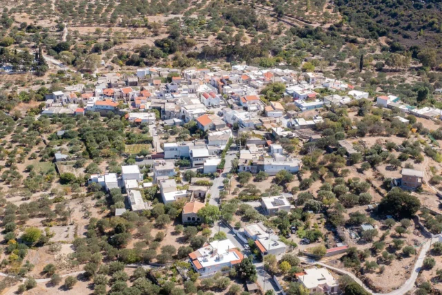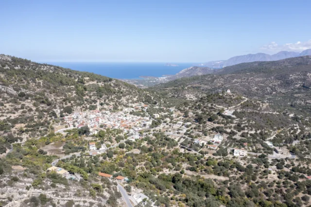
Gournia is located on the north coast of the Isthmus of Hierapetra in East Crete, west of the modern village of Pacheia Ammos. It lies in the Mirabello region.
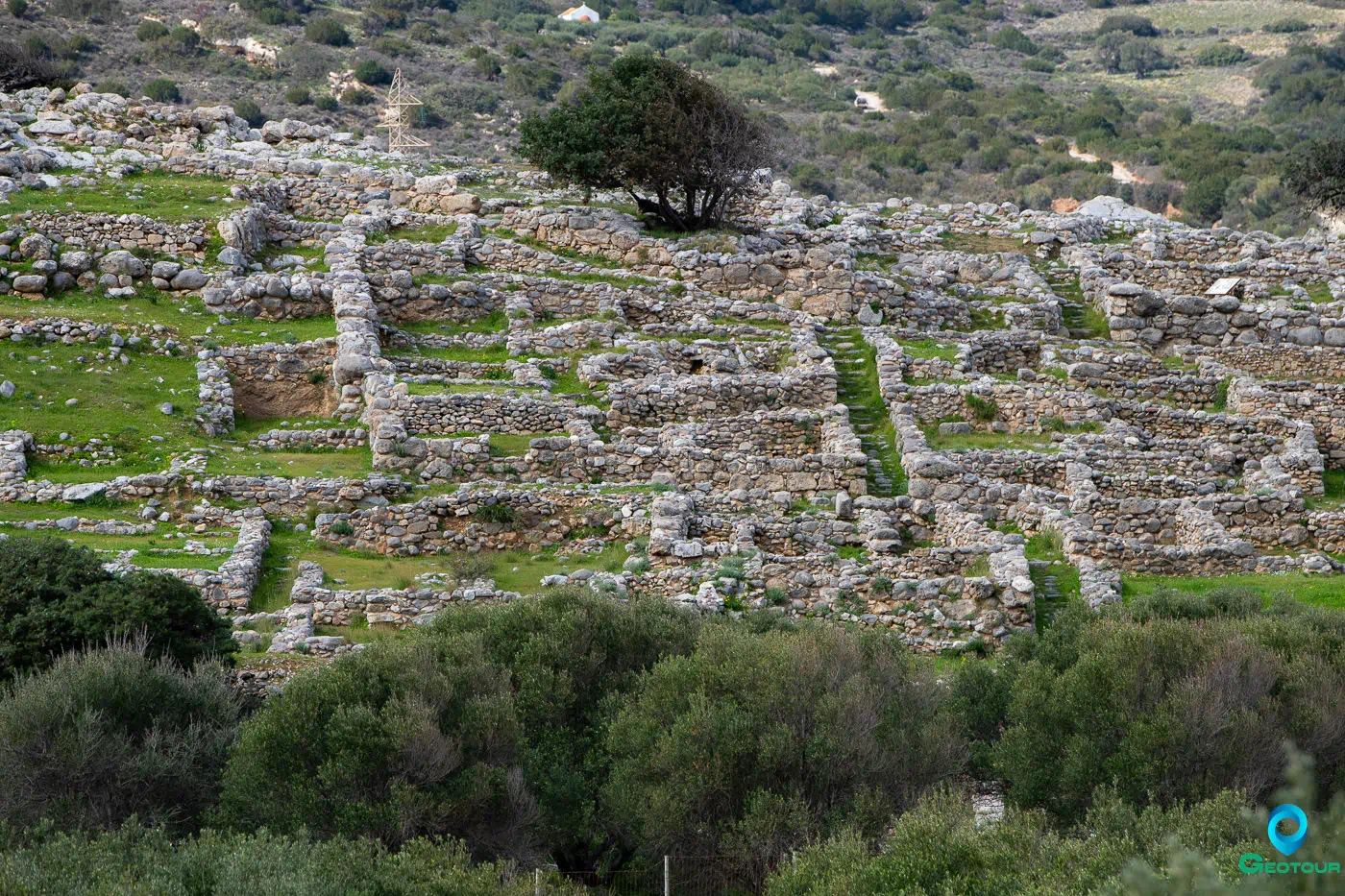
Gournia is a Minoan town that represents a complete example of a small Minoan settlement with narrow, winding streets, houses, a modest palace, and a town square. It was a social community where human interactions shaped shared memories. The site has been a key reference point for understanding Minoan urbanism for over a century.
Delving into the history of excavation and research at Gournia reveals a layered and evolving understanding of this Minoan settlement. The initial investigations by Harriet Boyd Hawes laid the groundwork, while subsequent projects and ongoing work continue to refine and deepen our knowledge.
History of Excavation and Research
Early Excavations
Harriet Boyd Hawes initiated the first systematic excavation at Gournia, undertaking three seasons of fieldwork in 1901, 1903, and 1904. These early excavations brought to light several key features of the site, including what was interpreted as a “palace” atop the settlement’s “acropolis,” as well as two cemeteries, known as Sphoungaras and the North Cemetery. Additionally, Hawes’ team uncovered more than 60 houses arranged in distinct blocks, connected by a street network. Her work provided the initial framework for understanding Gournia as a complete example of a small Minoan town. The documentation and findings from these early excavations are compiled in the publication “Gournia, Vasiliki and Other Prehistoric Sites on the Isthmus of Hierapetra”.
Later Investigations
Following Hawes’ pioneering work, supplementary excavations and investigations were carried out at Gournia. These included further excavations in the Sphoungaras cemetery and the North Cemetery, yielding additional insights into mortuary practices. A reinvestigation of the “palace” area was also undertaken, with a focus on understanding its architectural phases and functions.
In addition to targeted excavations, an intensive survey of the broader Gournia region was conducted. This regional survey aimed to contextualize Gournia within its surrounding landscape, examining settlement patterns, economic activities, and environmental factors.
Further work involved an investigation of the harbor area, seeking to understand Gournia’s maritime connections and its role in regional trade networks. This work led to the conclusion that the history of Gournia was deeper and more complex than previously believed.
From 2010 to 2014, L. Vance Watrous initiated a five-year excavation project, prompted by tantalizing information from the additional studies, which included a complete reexamination of the site’s architecture.
Current Projects
Currently, the Gournia Excavation Project (GEP), under the direction of L. Vance Watrous, continues to explore and document the site. This ongoing project is building upon the earlier work by creating a new GIS-based plan of the entire site. This updated plan, combined with excavation data, offers a more comprehensive and accurate representation of Gournia’s layout and architectural features. The detailed architectural analysis being conducted is associated with John McEnroe.
The integrated dataset is useful for inter-island and cross-cultural comparisons of urban development and change. This contemporary research seeks to understand how Gournia fits within the broader context of Minoan civilization and its connections to other settlements in the Aegean. The ongoing Gournia Excavation Project is reevaluating the architecture at the site.
Topographical Framework
Gournia’s topographical framework is defined by its coastal setting, natural boundaries, and key geographical features, which together shaped its development and role within the Minoan world.
Coastal Setting and Boundaries
Gournia occupies a small lowland coastal strip. This strip is bounded by the Selli and Phylakio mountains to the east and northeast, and by lower hills to the west. The location provided access to coastal shipping routes and local fishing. The land around Gournia is described as a “basin,” open to the sea on the north side, but enclosed by limestone massifs on the other three sides. This basin creates a visually self-contained world. The fertile plain of Assari lies to the south, while the Isthmus of Hierapetra is to the east.
Key Topographical Features
The main hill of Gournia and the hill of Pera Alatzomouri are prominent features in the area. The main hill is located almost in the middle of the lowland strip, while Pera Alatzomouri lies further to the north and east, just above the steep coast. The uplands define the horizon around these hills.
It is possible that a harbor existed in the Bronze Age at the mouth of a perennial river, now dry. The coastal building, referred to as “Shore House,” suggests the presence of a harbor, along with aerial photographs indicating buildings similar to Late Minoan galleries.
Landscape and Cultural Connections
The landscape around Gournia, including the basin and the coastal strip, was a balance between the natural and cultural elements. The stream west of the town, now dry, once ran from the springs at Asari to the sea. Modern irrigation supports olive groves, vineyards, fields, and gardens. The ancient road along the coast likely followed the route of the modern road, connecting Gournia to the broader region. The Shore House and coast suggest interactions with the outside world.
Agricultural and Economic Basis
The intermediate zone of lowland hills may have provided a subsistence basis for the inhabitants, similar to the ring of hills at Mochlos. Before modern irrigation systems, the lowlands might have provided a subsistence base for the Bronze Age inhabitants. There was little evidence of substantial Neolithic occupation of the Gournia area, but Final Neolithic deposits have been found in a small cave at Pera Alatzomouri.
Settlement Patterns and Regional Context
Gournia may have been the only Neopalatial settlement within its coastal basin. Pera Alatzomouri could have accommodated another settlement site, possibly dating to EM IIB-III, but its relationship to the main settlement is obscure. Communities in the area may have been small, consisting of no more than 3-6 houses.
Historical Periods
Gournia’s history spans several key periods, each leaving its mark on the town’s development and character. From its early beginnings as a small settlement to its peak as a regional center and eventual decline, Gournia reflects the broader patterns of Minoan civilization.
Early Habitation and Growth
The story of Gournia begins in the Neolithic period, with evidence of early activity found near Rock Shelter I at Sphoungaras. This suggests that the area was inhabited or used in some way during this time, although details about the nature of this early presence are limited.
During the Early Minoan (EM) period, specifically EM II and EM III, Gournia started to take shape as a small settlement. Deposits found on the western slope of the Gournia hill indicate that people were living and working in the area, though the scale of this early settlement was modest.
Expansion and Transformation
The Middle Minoan (MM) period saw significant changes at Gournia. During MM I, the settlement expanded, and there is evidence of construction in a few houses on the hill. However, the most dramatic growth occurred during the MM IB-II period, with signs of considerable expansion. It was during the Protopalatial period that the foundations of the later Neopalatial town were laid. This period marked a time of significant transformation and development at Gournia.
Flourishing and Destruction
The Late Minoan (LM) period represents the peak of Gournia’s prosperity. The town expanded significantly during the Neopalatial period, covering about four hectares. A ‘palace’ was constructed, and a paved road system was implemented. This was a time of great activity and growth for Gournia, with the town becoming a major center in the region.
However, this period of prosperity came to an end with the destruction of Gournia and other large sites in the Mirabello region at the close of the Late Minoan IB period. This event marked a turning point in Gournia’s history, leading to a period of decline and abandonment.
Decline and Limited Reoccupation
Following the destruction at the end of LM IB, Gournia experienced a period of decline. The coastal plain was largely abandoned during Late Minoan IIIA, and many of the settlements in the region were reduced in scale. Though some settlers returned during the Late Minoan IIIA-IIIB period, occupying a few houses and constructing a monumental corridor, the settlement never fully recovered. Eventually, this settlement was abandoned, bringing an end to the continuous changes that had characterized Gournia’s history.
Archaeological Discoveries
Archaeological discoveries at Gournia have provided a detailed view of a Late Bronze Age town in the Aegean, shedding light on its settlement layout, notable artifacts, architectural remains, and current state.
Excavations have unveiled a settlement that includes houses, a ‘palace’, a paved road system, and cemeteries. Harriet Boyd Hawes’s work uncovered a “palace” atop the settlement’s “acropolis”, along with two cemeteries (Sphoungaras and the North Cemetery), over 60 houses arranged in organized blocks, and a street network that connected the town. The “palace,” situated on the summit of Gournia hill, functioned as a central hub for agricultural storage and ritual performances, featuring elements like a central hall, residential quarters, banqueting halls, ritual spaces, and storerooms. Neopalatial houses were characterized by neat, regular walls, carefully cut thresholds, and reused ashlar blocks, with white crystalline monumental rubble used in wall construction throughout the site. A paved road system, constructed during the Neopalatial period, facilitated communication within the town. Possible remains of a ‘Shore House’ suggest a contemporary port existed at the mouth of the river.
Among the notable artifacts discovered, Middle Minoan IIIA cups and bowls, along with burned organic remains from a feast, were found in Room 13, interpreted as a building deposit. Additionally, a bench shrine on the acropolis contained statuettes of “goddesses”, figurines, and snake tubes.
The current state of the site reveals a detailed picture of a Late Bronze Age town in the Aegean. However, the bones in the North Cemetery were found in disarray due to disturbance and erosion. Gournia was more than just buildings; it functioned as a social community with shared memories. The West Court was an integral part of the town, facilitating the flow of people, ideas, and ceremonies. The decision to juxtapose the ancient façade with new ashlar masonry near the West Court suggests an attempt to connect viewers with the past. During Late Minoan III, a bench shrine with statuettes of goddesses, figurines, and snake tubes was established on the acropolis, overlooking the ruins of the Neopalatial civic landscape. Two cemeteries united the townspeople and confirmed hereditary rights to the land. The contents of Gournia’s House Tombs included prestige objects like gold and silver beads, a silver kantharos, copper-alloy implements and tools, and ivory. The North Cemetery included rock shelter burials and ostentatious house tombs. The Sphoungaras Cemetery featured rock shelter burials, direct inhumations, larnax burials, and Cycladic-style cist burials. A dramatic change in mortuary activity occurred in Middle Minoan II, coinciding with the town’s transformation through the construction of the first palace, monumental houses, and a paved street system. The Sphoungaras Cemetery ceased to be used at this time, while wealthy burials continued in the house tombs in the North Spur. Pithos burials became the predominant form of burial in the Sphoungaras cemetery. No funerary remains from the Late Minoan IA through IB periods have been recovered at Sphoungaras.
Cultural and Economic Context
Gournia existed within a cultural and economic context that was defined by its connections to other sites, economic activities, and cultural practices. Gournia had links to other East Crete locations, including Mochlos, Pseira, and Vasiliki. It may have exerted control over the Northern Isthmus, overseeing the Myrtos valley and Mochlos. This is further supported by the fact that sandstone ashlar blocks used to refurbish the palace came from a Mochlos quarry.
Evidence points to regional trade, particularly with the Cyclades, involving the import of obsidian and gold. Gournia may have been the only Neopalatial settlement within its coastal basin.
Building deposits, such as the one discovered in Room 13, indicate communal events and dedications. Feasts may have been held to celebrate the completion of the palace’s southern extension. Funerary performances took place in the North Cemetery. Religious practices are indicated by the presence of a bench shrine containing statuettes and figurines.
Settlement Layout and Urban Planning
Gournia demonstrates features of settlement layout and urban planning in Minoan Crete. The town’s street network formed organized housing blocks, with smaller streets and alleyways providing access. A main street ran north-south, providing access to large urban blocks. The deliberate construction of urban elements influenced the overall layout of the city.
The streets served not only as passageways but also as social spaces where relationships were organized and reinforced. The main street led to the palace and central courtyards, highlighting these complexes as significant destinations. The design and construction of buildings reflected a common orientation to the palace, which may have been dictated by topography. The street system provided coherence and unity to different structures within the settlement.
Overall, the urban features were carefully constructed, affecting the general layout and helping to structure the city.
Key Points
- Location and Accessibility: Gournia is located on the north coast of the Isthmus of Hierapetra, offering access to both the coast and inland areas.
- Active Historical Periods: The site was most active from the Early Minoan II to the Late Minoan IB periods.
- Historical Significance: Gournia is significant as a complete example of a small Minoan town and a key site for understanding Minoan urbanism.
- Current Status: The site has been the subject of extensive archaeological investigation, with ongoing projects aimed at reexamining its architecture and understanding its development.
References
- Eleni Hatzaki. “Visible and Invisible Death. Shifting Patterns in the Burial Customs of Bronze Age Crete.” In From the Foundations to the Legacy of Minoan Archaeology: Studies in Honour of Professor Keith Branigan, edited by Maria Relaki, Giannēs Papadatos, and Keith Branigan, 190–209. Sheffield Studies in Aegean Archaeology 12. Oxford ; Philadelphia: Oxbow Books, 2018.
- S. Jusseret and M. Sintubin, Eds., Minoan Earthquakes: Breaking the Myth through Interdisciplinarity. Leuven University Press, 2017. doi: 10.2307/j.ctt1whm9cf.
- D. Matthew Buel, 2015. Minoan Cityscapes: Urban Planning in Neopalatial Crete.
- Buell, D.M., McEnroe, J.C., 2017. Community Building/Building Community at Gournia, in: Minoan Architecture and Urbanism. Oxford University Press. https://doi.org/10.1093/oso/9780198793625.003.0016
- Bonney, E.M., 2005. A Reconsideration of Depositional Practices in Early Bronze Age Crete.
- Giorgos Vavouranakis, 2007. Funerary Landscapes East of Lasithi, Crete.
- Driessen, J., Langohr, C., n.d. RECENT DEVELOPMENTS IN THE ARCHAEOLOGY OF MINOAN CRETE.