A Village by the Lake
Agia is a village located in the Chania municipality of the Chania regional unit, Crete. It sits in a fertile plain at an altitude of 50 meters, approximately 10 kilometers southwest of Chania town. Known for its proximity to the artificial Lake Agia and its historical significance as a former episcopal see, Agia offers a blend of natural beauty and cultural heritage.
Etymology
The village’s name, Agia, is believed to derive from the Arabic word “aya,” meaning “water,” likely referencing the abundance of springs in the area.
Historical Overview
Byzantine Era: After the Byzantine reconquest of Crete by Nikephoros Phokas in 961 AD, the episcopal see of Kydonia was relocated to Agia due to the threat of pirate raids along the coast. This move highlights the historical importance of Agia as a safe and fertile inland settlement.
World War II: During World War II, the area around Agia witnessed fierce battles between German paratroopers and the defenders of Crete (Cretans and Allied forces) in May 1941. The village’s agricultural prison was used to hold many Greek patriots during the German occupation, some of whom were executed.
Modern Era: In 1925, Agia (initially recorded as “Agyia”) was officially recognized as a settlement and attached to the community of Alikianos. Its name was corrected to “Agia” in 1940. In 1946, it became the seat of its own community. With the Kapodistrian administrative reform in 1997, Agia joined the municipality of Theriso. In 2010, it became part of the Chania municipality.
Population Data
Year |
Population (Village) |
Population (Community) |
|---|---|---|
1961 |
240 |
454 |
1971 |
251 |
429 |
1981 |
236 |
394 |
1991 |
280 |
456 |
2001 |
353 |
553 |
2011 |
428 |
588 |
2021 |
418 |
Points of Interest
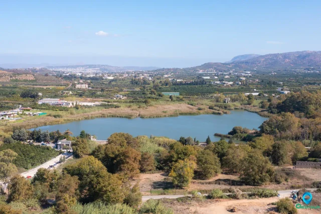
- Lake Agia: An artificial lake covering approximately 450 hectares, created to supply water to the Chania aqueduct and hydroelectric plant. The lake is an important resting and feeding ground for migratory birds. However, in recent years, parts of the lake have become swampy, and there are concerns about the introduction of non-native plant and animal species.
- Paleochristian Church of Panagia Episkopi: A historic church dating back to the early Christian period, showcasing the long religious history of the area.
- Church of Agios Konstantinos and Agia Eirini: A more modern church serving the religious needs of the community.
- Old Watermill: Remnants of a watermill, a reminder of the agricultural past of the village.
- Prison: The area also houses a prison facility.
Village Key Points
- Historical References: Historically significant as the former seat of the Bishop of Kydonia.
- Location: Chania regional unit, Crete, Greece. 10 km southwest of Chania town.
- Altitude: 50 meters above sea level.
- Historical Significance: Played a role in World War II, with battles fought in the surrounding area.
- Current Status: A village with a mix of agricultural and residential areas, known for its proximity to Lake Agia.