


Important Advisory: This route planner is designed for preliminary itinerary creation and should not be used for precise, turn-by-turn navigation. Many points of interest on GeoTour.gr may be located in areas accessible only by hiking or with a four-wheel-drive vehicle. While the Google Maps export provides a useful alternative for navigation, users must always exercise common sense and conduct thorough preparation to ensure a safe trip.
Route Planner Now Integrated into the Main Map
The route planning functionality on https://www.geotour.gr has been updated and enhanced. The feature, which was previously available as a separate, standalone widget, is now fully integrated into the main website map. This integration streamlines the workflow, allowing users to build, view, and modify their travel plans directly within the primary map interface without navigating to a different page.
This tool enables users to create custom travel itineraries by selecting points of interest directly from the map, calculating travel logistics, and exporting the final plan for practical use.
Core Features of the Route Planner
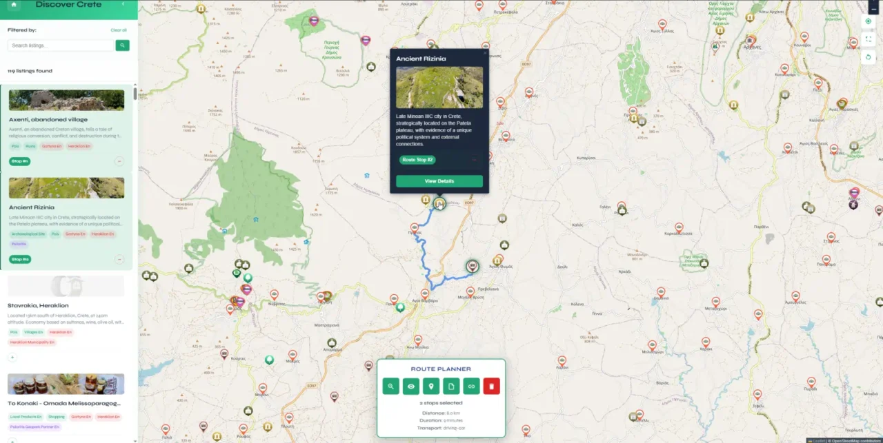
The Route Planner is equipped with a set of functions designed to cover the entire process of itinerary creation, from initial point selection to sharing and saving the completed route. The initial point can be any listing by selecting the respective button on the map of the listing info page, which will open the map and add the listing as the first stop of the route.
These tools provide the necessary data and flexibility for effective trip planning.
- Create Custom Routes
This is the fundamental capability of the planner. Users can add any point of interest shown on the map to a route. This allows for the construction of highly personalized itineraries that can be tailored for single-day trips, multi-day tours, or longer excursions based on specific interests and time constraints. - View Travel Times and Distances
For logistical planning, the Route Planner calculates and displays the total distance and estimated travel time for the entire route. This calculation is powered by the OpenRouteService API (https://openrouteservice.org), a robust routing engine that provides turn-by-turn directions with multiple transportation profiles (driving, cycling, and walking) and automatically optimizes the path between selected waypoints. - Export to Google Maps
To bridge the gap between planning and on-the-ground navigation, any created route can be directly exported to the Google Maps mobile application. This function generates a URL that, when opened on a mobile device, loads the selected stops into Google Maps, allowing for familiar and reliable turn-by-turn navigation. - Share Itineraries
A completed route can be easily shared by generating a unique URL. This link contains the stop data, allowing recipients to view the exact itinerary. This is useful for coordinating with fellow travelers or for saving a plan for future access without needing to log in or save the file locally. - Save Your Route
For archival purposes or use in other applications, a route can be downloaded as a GeoJSON file. GeoJSON is a standard format for encoding geographic data structures. This allows users to store their routes permanently or import them into other GIS software (like QGIS) or mapping platforms for more advanced analysis.
How to Use the Integrated Route Planner
All route management is now handled through direct interaction with map markers and a dedicated on-screen toolbar that becomes active once you begin planning. The process is designed to be intuitive and map-centric.
Adding Locations to a Route
- Navigate the map to find a point of interest.
- Select its marker to open the details pop-up.
- Select the “Add to Route” button. The location will be added to the current itinerary.
Changing the Order of Stops
- In the location’s pop-up, select the “Route Stop #X” identifier.
- Enter a new number to reassign its position in the sequence.
- The order of the remaining stops will update automatically to reflect the change.
Removing a Stop
- Select the marker of a location that is already part of your route.
- Select the “Remove from Route” button in the pop-up window.
Using the Route Toolbar
When the first stop is added to a route, a toolbar appears at the bottom of the screen. It provides centralized control over the entire itinerary.
- Zoom to Route: Automatically adjusts the map’s zoom level and center to display all stops in the current route.
- Preview Route: Renders the calculated path connecting all stops on the map. This visual preview is generated using the routing engine from OpenRouteService to show the most efficient path.
- Google Maps: Exports the current set of stops to Google Maps for mobile navigation.
- Download: Initiates the download of the route as a GeoJSON file for local storage.
- Share: Generates a unique, shareable URL for the current route.
- Clear: Deletes all stops from the current route. This action is irreversible.
Planning Tips
- Stops can be added in any order and reorganized later.
- Use the “Preview Route” function to verify that the path and total travel time are suitable for your schedule.
- Use the “Zoom to Route” function to get a complete overview of your itinerary.
- For longer journeys, it is advisable to segment the route into several single-day itineraries.