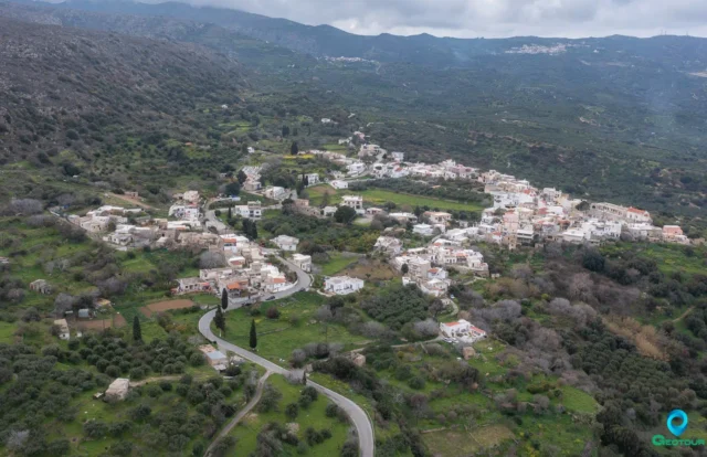
The village of Mesa Mouliana is situated on the northern side of the eastern part of the island of Crete, in the regional unit of Lasithi. It lies along the National Road connecting the rest of the island with Sitia, and is about 19 kilometers from Sitia, 51 kilometers from Agios Nikolaos, and 118 kilometers from Heraklion.
Historical Points
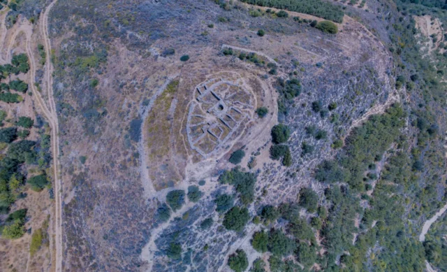
- The area around Mesa Mouliana has been inhabited since the Minoan period, as evidenced by findings from various archaeological sites like Selades, Vourlia, Gouves, and Ellenika.
- In 1903, two Late Minoan tholos tombs with evidence of continuous burials extending into the Protogeometric period were excavated in Selades. The discovery of a Protogeometric krater depicting a hunter and a rider on horseback is significant, as it is the first known depiction of a mounted man in Crete.
- The village’s name is believed to be derived from the family name Mouliani, which also gave its name to the nearby village of Exo Mouliana.
- The first written mention of the village dates back to 1370, where it is referred to as Muliana. In a 1583 census, Mesa Mouliana was recorded as having 749 inhabitants, making it the largest village in the Sitia province at the time.
Economy
- The primary occupations of the residents are grape cultivation for wine and raki production, and olive cultivation for olive oil production.
- The village is known for its Moulianitiko wine, made from Liatiko grapes grown in the Agrilis region, a location well-suited for viticulture situated slightly above the village.
Powered by GetYourGuide
Points of Interest
- The old church of Agia Triada houses remnants of wall paintings in its central aisle.
- Kryfos Spilios (Hidden Cave) shows signs of habitation from the Late Minoan period.
- A well-preserved Ottoman fountain is located in the village center.
- Kefalovrysi, a spring with running water surrounded by a tavern and lush flora, is a popular spot in the village.
Settlement: Key Points
- Historical References: First mentioned in 1370; 1583 census records 749 inhabitants.
- Location: Lasithi regional unit, Crete, Greece.
- Historical Significance: Archaeological findings suggest inhabitation since the Minoan period; was the largest village in the Sitia province in the 16th century.
- Population: As of 2021, 288 people.
Population Data
Year |
Population |
Notes |
|---|---|---|
1583 |
749 |
as Mugliana messa |
1881 |
486 |
472 Christians, 14 Muslims |
1900 |
450 |
|
1920 |
459 |
|
1928 |
456 |
|
1940 |
512 |
|
1951 |
517 |
|
1961 |
483 |
|
1971 |
384 |
|
1981 |
331 |
|
1991 |
302 |
|
2001 |
279 |
|
2011 |
208 |
|
2021 |
288 |
References