


227
listings found
Categories
Active filters:
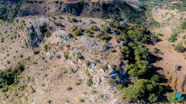
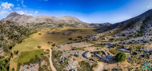
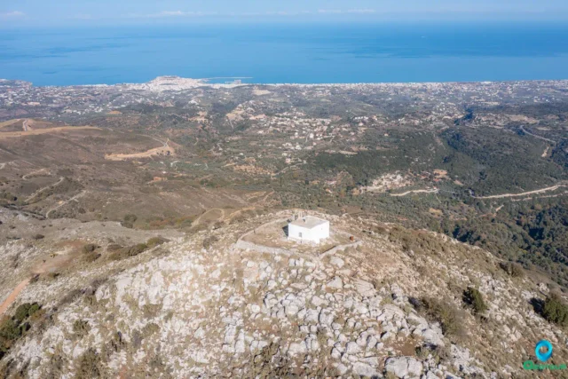
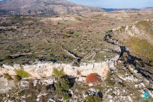
Bonriparo Fortress near Monopari
The Bonriparo fortress, on Kastellos hill near Monopari, is a strategic stronghold 16km south of Rethymno. Its origins are debated: either Genoese by Enrico Pescatore (1206) or from the Second Byzantine Period as the Tower of Melissinos. The Venetians later modified it. The fortress was the catalyst for the major "Revolt of the Two Syvritos" (1217-1236), started by the Skordilis family. It controlled the Amari valley route and formed a defensive network with Syvritos and Kiriakoselia. Its ruins include a two-meter-thick northern wall, a central Byzantine-era tower, and large cisterns.
Nisi, abandoned settlement
An uninhabited settlement in Crete, located in the Argyroupoli area of Rethymno on the Nisiiani mountain, separating the Kollita Gorges. Officially abolished in 1961, its history may date to the Byzantine era, with the first written record in a 1583 census by Kastrofylakas. The ruins, found along the E4 European path, include well-constructed stone houses with arches and carved details. Within the site is the church of Agios Georgios, with the church of Panagia i Nisiani located nearby.
Grivila ancient city and Melidoni cave
An Early Iron Age settlement on a hill in the Mylopotamos plain, occupied into the Late Geometric period. The site featured tightly packed, single-story houses built with small stones and had beaten earth floors. Excavations unearthed finds like a bronze hoplite statuette, Geometric sanctuary figurines, and coarse pottery. The nearby Melidoni cave, a cult place since Minoan times, is thought to have served as the settlement's sanctuary, a common pattern in ancient Crete.
Agios Georgios, Rethymno
A traditional settlement in Rethymno, Crete, at an altitude of 260 meters within the Community of Agios Konstantinos. It is documented in Venetian records by Barozzi in 1577 as S. Zorzi Messoghoriti and Kastrofylakas in 1583. During the Ottoman era, some inhabitants converted to Islam following the 1770 revolution. By the 19th century, it had a mixed Christian and Turkish population. Nearby are the ruins of Artos village, which features the Church of Agios Georgios, built in 1401 with preserved frescoes.
Kato Valsamoneron, Rethymno
Located 14km from Rethymno at an altitude of 250 meters, its name derives from the aromatic balsam plant. First mentioned in 1577 by Francesco Barozzi, it was a significant Venetian military sector. During the Ottoman period, its Christian inhabitants were replaced by Turkish settlers. It was resettled by Cretan families in the early 20th century. Points of interest include the church of Agios Ioannis, with frescoes dating to the 12th-14th centuries, and the Vasile cave, site of a 1944 Pan-Cretan Resistance Conference.
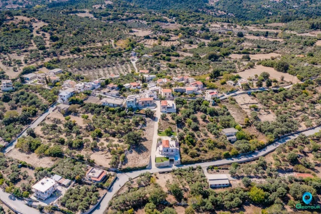
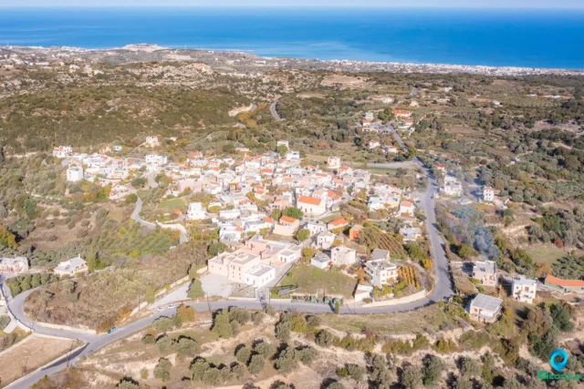
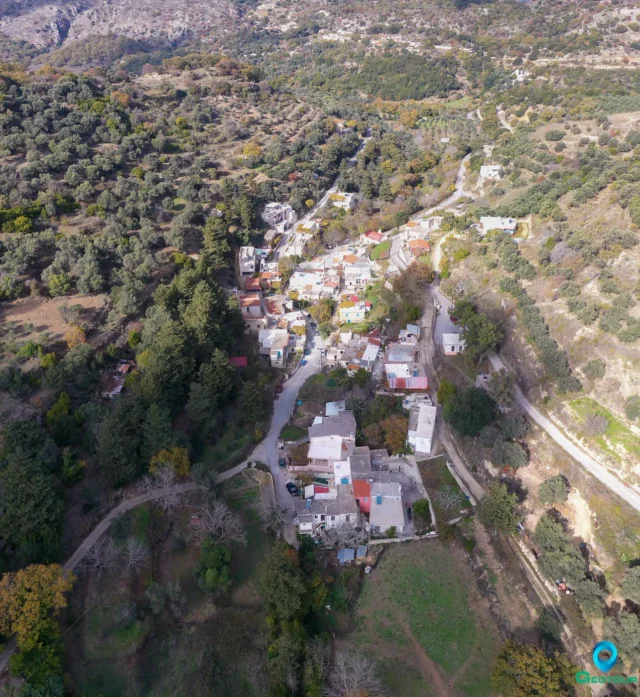
Monopari, Rethymno
A semi-mountainous village in Rethymno, Crete, at an altitude of 380 meters. Its name is a corruption of "Castello Bonriparo," a fortress on a nearby hill. This fortification was central to the "Revolution of the Two Syvritoi" (1217-1236), a major uprising by the Skordilis and Melissinos families against the Venetians. The conflict ended with a treaty granting significant rights to the Cretan lords. Administratively, the settlement belongs to the community of Ano Valsamonero.
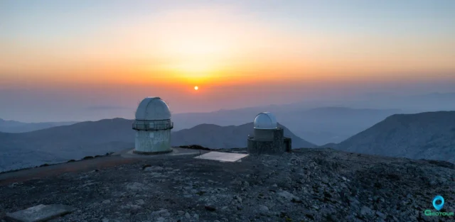
The Summit of Skinakas Skinakas Observatory
At 1,750m on Psiloritis, a UNESCO Global Geopark, the peak offers panoramic views of Crete. The site hosts the Skinakas Observatory, founded in 1984 by the University of Crete, FORTH, and Max Planck Institute. It features a 1.3m telescope and the new 1.0m "200+" telescope. Powered by a photovoltaic park since 2000, it has produced numerous scientific publications. The observatory hosts public "Open Nights" and maintains strong ties with the nearby village of Anogeia.
Nida mountain plateau
The Nida Plateau is a large polje at an average altitude of 1,400 meters in central Crete’s Psiloritis massif, a key part of the Psiloritis UNESCO Global Geopark. Its creation resulted from the Idaion Fault and karstification processes. The plateau is a critical water source for the region, with water vanishing into sinkholes. It is home to the Ideon Andron, the mythological cave where Zeus was raised, which was a major religious sanctuary for 3,000 years. The local culture is defined by its stone shepherd's huts (mitata).

Ancient Lappa
Beneath Argyroupoli, Rethymno, between the Petres and Mousselas rivers, this city had Geometric to Byzantine occupation. A Roman civitas libera under Augustus, with Italian settlers and Agrippa's patronage, it faced Arab destruction (828 AD). Rescue digs revealed Hellenistic fortifications, homes, Roman baths, and a still-used cistern. Material culture includes skyphoi, Italian/Eastern sigillata, stamped amphorae (Rhodes, Knidos), local pottery, coins, and an Aphrodite statue. A key trade hub on Crete's Roman road.
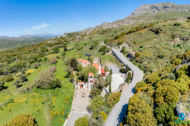
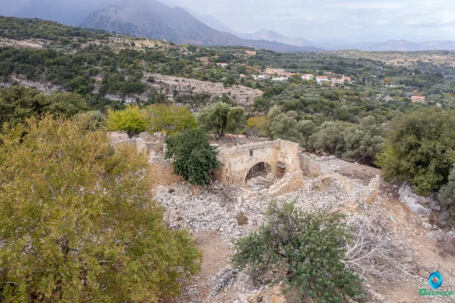
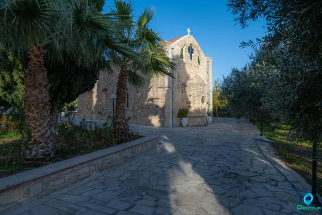
Monastery of the Holy Spirit
Located near Kissos, Rethymno, on Mount Kentros, this Orthodox monastery, possibly dating to the Byzantine era and active during Venetian times, was destroyed in 1821. It later became the significant "School of the Holy Spirit" in 1836 under Ottoman rule, educating figures like Emmanouil Tsouderos. A memorial marks an 1868 battle site. Declared a protected monument in 1980, it is now restored and reopened, with an Abbot appointed after nearly 200 years. It falls under the Metropolis of Lambi, Syvritos and Sfakia.
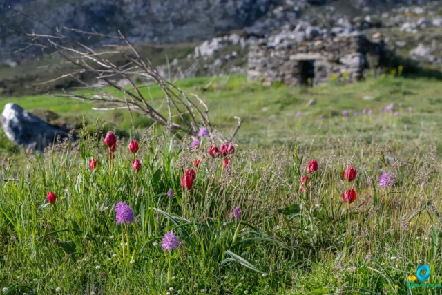
The Gious Kampos Plateau
Gious Kampos is an ecologically important high-altitude plateau (750m avg. elevation) in the Amari Valley administrative area, Rethymno, Crete, situated on the northwest side of Mount Kentros. Its geology, combining clay rocks with limestone outcrops, fosters unique hydrology and fertile soil. The name potentially derives from "Plain of Eos" (dawn) or "Plain of the Goats." Designated a Natura 2000 site, it's renowned for exceptional biodiversity, serving as the primary habitat for the protected endemic Cretan red tulip, Tulipa doerfleri. The plateau also hosts a remarkable density and variety of orchids, including Orchis italica and Neotinea tridentata. Historically and currently vital for agriculture (cereals, vegetables, fruit trees) and pastoralism for surrounding villages like Spili and Kissos.
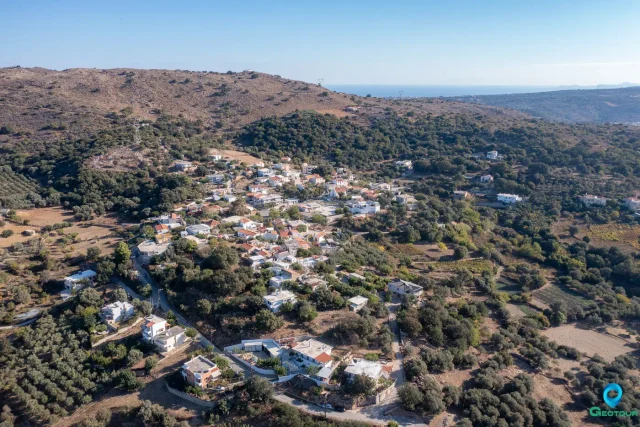
Selli, Rethymno
Selli (Σελί) is a village situated in the Rethymno regional unit on the island of Crete, Greece. It is located approximately 17 kilometers southeast of Rethymno town, nestled in the […]
Chromonastiri, Rethymno
Chromonastiri is a traditional Cretan village with a rich history dating back to the 12th century. It's located 11 kilometers southeast of Rethymno, near Mount Vrysinas. The village is known for its Venetian-era architecture, particularly the restored Villa Claudio, now home to the Chromonastiri Military Museum.
Chromonastiri also boasts several significant Byzantine churches, including the 11th-century Church of Panagia Kera with its unique architectural features and surviving frescoes. The Church of Agios Eftychios at Perdiki Metochi is another notable Byzantine church, featuring impressive frescoes and a distinct folk art style.
The village square houses the renovated Prinari olive mill, now an educational center showcasing the history of olive oil production and traditional Cretan life. Chromonastiri is a designated traditional settlement, offering visitors a glimpse into Crete's cultural heritage through its architecture, religious sites, and historical landmarks.
Vrysinas Peak Sanctuary
The Vrysinas Peak Sanctuary, located on the slopes of Mount Vrysinas in Crete, is a significant archaeological site that offers valuable insights into Minoan religion and culture. Excavations have revealed a wealth of artifacts, including human and animal figurines, pottery, horns of consecration, and a fragment of a libation table with a Linear A inscription. The sanctuary's unique position as the sole Neopalatial peak sanctuary in the region highlights its importance in the religious landscape of Minoan Crete. The site is easily accessible to visitors and provides a fascinating glimpse into the spiritual world of the Minoans.
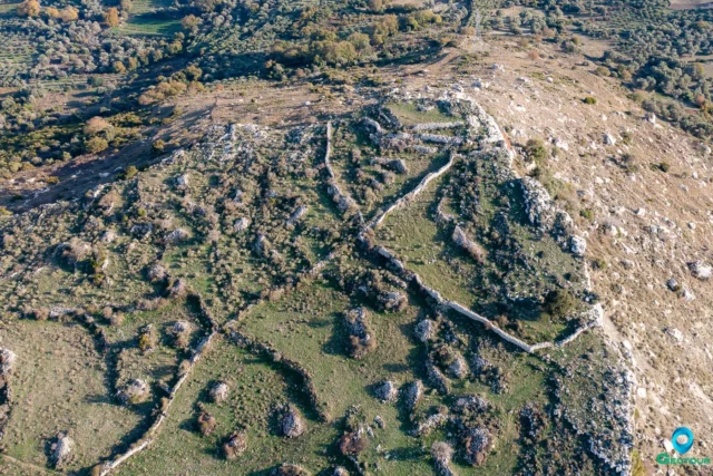
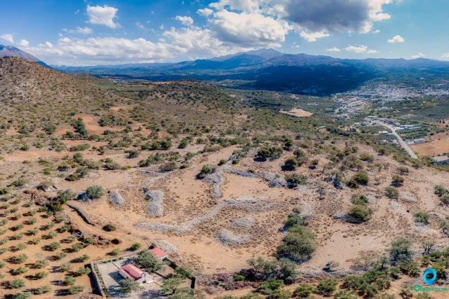
The Acropolis of Onithe
The Acropolis of Onithe, a Hellenistic-era fortress potentially dating back to 1400 BC, occupies a strategic position on the Onithe plateau at 638 meters elevation. The site features a pseudo-isodomic wall enclosing a right-angled area with 12-meter sides and remnants of a defensive tower. A steep, natural cliff forms the southern boundary of the acropolis. The site's location provided control over key passages and access to the settlement, underscoring its strategic significance in ancient Crete. Pottery finds suggest the possibility of earlier settlement phases dating back to the Proto-Minoan and Late Minoan periods. The acropolis, referred to locally as 'Ntapia,' meaning fortification, likely played a role in Cretan revolts in 1821, 1878, and 1897.
The Archaeological Site of Onithe
Onithe, an archaeological site near Goulediana in Rethymno, Crete, offers a glimpse into the island's history from the Neolithic period to the Venetian and Ottoman eras. Its strategic location on a plateau provided control over key passages and natural defenses. The site features ruins like the Acropolis with its pseudo-isodomic walls and tower, House A with its abundance of pottery and pithoi, an ancient spring and possible sanctuary, and a Paleochristian Basilica with well-preserved mosaics.
The ancient name of the city remains uncertain, with scholarly attempts to identify it as Osmida or Phalanna remaining inconclusive. It may have been an early settlement center for ancient Rhithymna. The site has yielded artifacts like pottery shards, a bronze zodiac, exquisite metalwork, and sculptures, providing evidence of its prosperity and cultural vibrancy throughout the Minoan, Archaic, Classical, Hellenistic, Roman, and Byzantine periods.
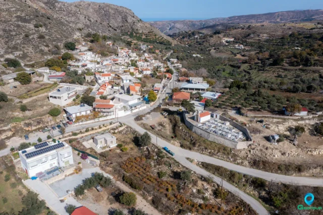
Goulediana, Rethymno
Goulediana, a small mountain village nestled in the Rethymno regional unit of Crete, Greece, presents a captivating blend of natural beauty and historical intrigue. Perched at an altitude of 540 meters in a small valley, this quaint village is located 18 kilometers from the city of Rethymno.
Though absent from Venetian censuses, Goulediana is believed to have existed as a metochi, a dependency of a monastery. The village's history stretches back to the Archaic period, as evidenced by the Onithi archaeological site southeast of the village. This site features remnants of a fortified acropolis, houses, and a monumental fountain dating to the 7th-6th century BC. Further historical significance is found in the Early Christian basilica at Kera Onithi, dating to the 5th century AD. Goulediana also boasts several churches of note, including the 1787 Agia Kyriaki with its sanctuary housed within a cave, Agia Varvara, and the Genethlio tis Theotokou. The wider Goulediana area encompasses churches such as the Panagia Kera, Zoodochos Pigi, Koimisis tis Theotokou, Agios Antonios (cave), and Metamorphosis tou Sotira. Despite its rich historical tapestry, Goulediana has experienced a declining population in recent years.
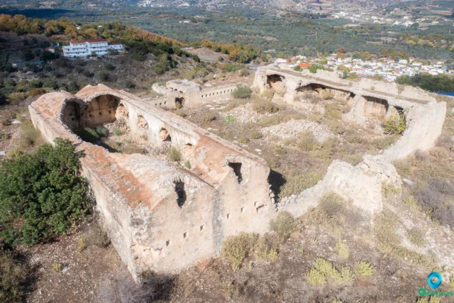
The Koules of Koxare
The Koules of Koxare is an Ottoman-era fortress located near Koxare village at the entrance of Kourtaliotiko Gorge in Rethymno Prefecture, Crete. Built between 1866 and 1869, it was part of a network of fortifications designed to control movement and quell rebellions on the island. The Koules is characterized by a large internal courtyard, thick stone walls, and remnants of arched structures. Partially destroyed in 1896 during the Cretan revolution, it stands as a testament to the island's struggle for freedom from Ottoman rule. Despite its deteriorated state, the Koxare Koules remains an important historical landmark with potential for preservation and tourism development.
Sata, Amari
Sata is a settlement located in the Rethymno regional unit on the island of Crete, Greece. It belongs to the Municipality of Amari