


748
listings found
Categories
Active filters:

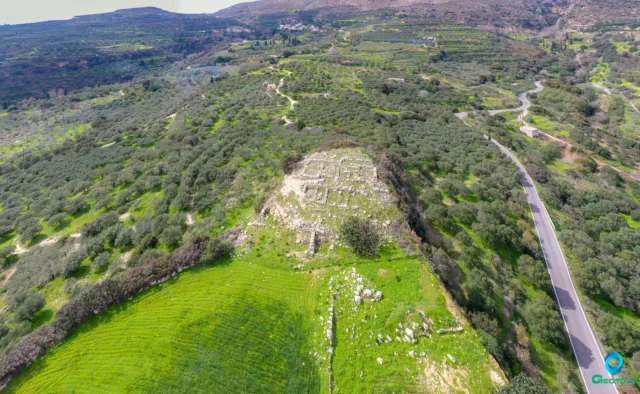
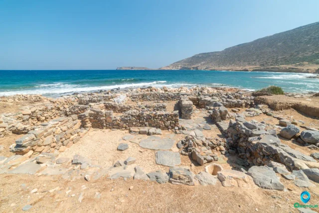
Ancient Lappa
Beneath Argyroupoli, Rethymno, between the Petres and Mousselas rivers, this city had Geometric to Byzantine occupation. A Roman civitas libera under Augustus, with Italian settlers and Agrippa's patronage, it faced Arab destruction (828 AD). Rescue digs revealed Hellenistic fortifications, homes, Roman baths, and a still-used cistern. Material culture includes skyphoi, Italian/Eastern sigillata, stamped amphorae (Rhodes, Knidos), local pottery, coins, and an Aphrodite statue. A key trade hub on Crete's Roman road.
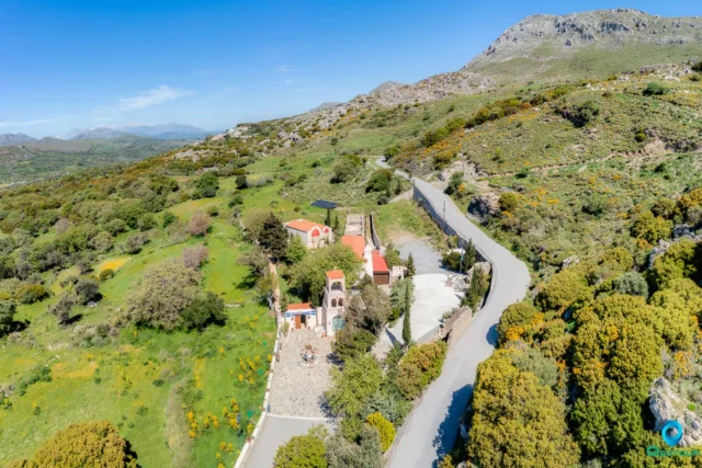
Monastery of the Holy Spirit
Located near Kissos, Rethymno, on Mount Kentros, this Orthodox monastery, possibly dating to the Byzantine era and active during Venetian times, was destroyed in 1821. It later became the significant "School of the Holy Spirit" in 1836 under Ottoman rule, educating figures like Emmanouil Tsouderos. A memorial marks an 1868 battle site. Declared a protected monument in 1980, it is now restored and reopened, with an Abbot appointed after nearly 200 years. It falls under the Metropolis of Lambi, Syvritos and Sfakia.
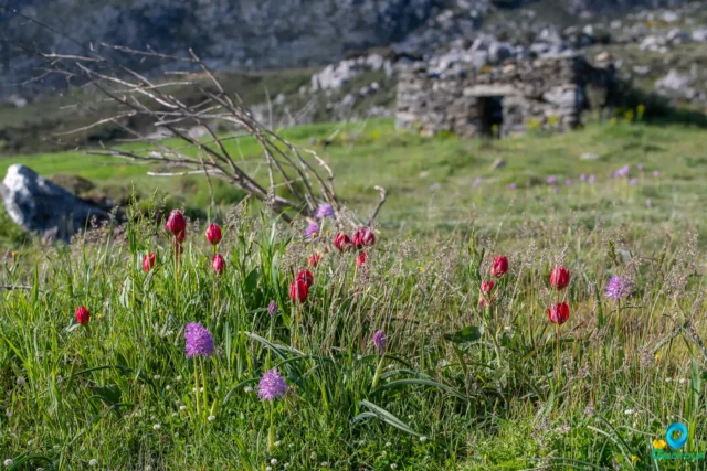
The Gious Kampos Plateau
Gious Kampos is an ecologically important high-altitude plateau (750m avg. elevation) in the Amari Valley administrative area, Rethymno, Crete, situated on the northwest side of Mount Kentros. Its geology, combining clay rocks with limestone outcrops, fosters unique hydrology and fertile soil. The name potentially derives from "Plain of Eos" (dawn) or "Plain of the Goats." Designated a Natura 2000 site, it's renowned for exceptional biodiversity, serving as the primary habitat for the protected endemic Cretan red tulip, Tulipa doerfleri. The plateau also hosts a remarkable density and variety of orchids, including Orchis italica and Neotinea tridentata. Historically and currently vital for agriculture (cereals, vegetables, fruit trees) and pastoralism for surrounding villages like Spili and Kissos.
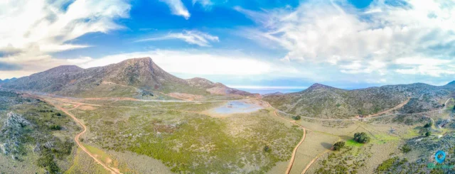
Strouboulas Massif
Located in Crete's Malevizi Province near Tylissos and visible from Heraklion, this mountain range features a prominent peak (798m) noted for its conical shape. Historically called "Stroggylo," Venetians named it after Stromboli. The range includes the Strouboulas plateau, south of the ridge, formed on limestone ("Tripoli" zone), leading to karstic features like the Tafkos tou Palmetis chasm, linked to Ottoman-era resistance. Vegetation is sparse, dominated by Kermes Oak due to overgrazing. A seasonal lake forms on the plateau, its water often reddish from soil runoff. Historical significance includes Minoan foothill settlements, the Timios Stavros chapel (Holy Cross) on the summit mentioned in 1415, possibly on an older site, and the Agios Georgios chapel ruins below, once a monastery dependency. Access to the peak involves a path from the plateau offering panoramic views.
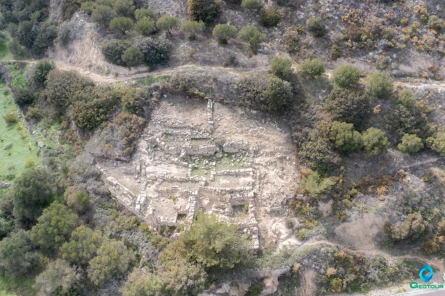
Minoan Villa at Agios Georgios (Tourtouloi)
Situated on Prophitis Elias hill near Praisos in eastern Crete, Agios Georgios, also known as Tourtouloi, is the site of a 700 square meter Minoan villa constructed across four terraces during the Bronze Age, specifically the Proto- and Neopalatial periods (MMIII to LMIB). Excavated by Nicholas Platon, this 'villa' functioned as a central building within a small settlement focused on agricultural exploitation. The site, part of the Petras region's settlement hierarchy, features architectural remains including rooms on the second terrace and a wine press and possible kitchen on the lowest. Discoveries include numerous loom weights, indicating significant textile production, and a potter's wheel, suggesting localized pottery manufacture. While not well-preserved due to landslips and weather, Agios Georgios represents a second-tier 'villa' site within the Petras territory, highlighting agricultural and craft activities within the broader Minoan economic and cultural context of eastern Crete.
Zou Minoan Farmhouse
Zou, an eastern Cretan Minoan site, features a Neopalatial farmhouse spanning MM IIIB to LM IA.
Excavations, including Platon's 1955 work and a 2004 re-examination, uncovered dark-on-light pottery and Linear A script fragments. Architectural remains reflect Minoan rural building practices. The site's location and artifacts provide insights into the area's economic and social roles during the peak of Minoan civilization, including the period surrounding the Thera eruption. Studies of Zou, alongside sites like Achladia and Epano Zakros, contribute to understanding Minoan settlement patterns outside major palatial
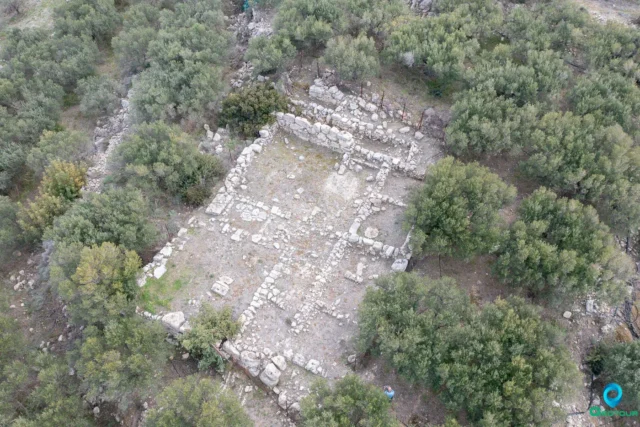
Achladia Minoan Villa
Achladia, 3 km from Achladia village, presents Minoan House A, a 270 sq m structure, dated LM I & III. Excavations since 1939 revealed artifacts like amphorae and larnakes, illuminating Minoan life and burial practices. The site's rectangular design, potentially based on the Minoan foot, and its internal layout around anteroom A, reflect sophisticated planning. Debates persist on its function as a villa, due to simpler construction compared to central Cretan sites. Re-examinations in 2003 analyzed topography, materials, and spatial use, aided by digital reconstructions. The location's visual range and wind-protected orientation are noted. Building materials, like local limestone and marls, and techniques, including megalithic walls, suggest practical construction. Achladia offers insights into East Cretan Minoan architecture and socio-political structures, with its status as a villa under scholarly scrutiny.
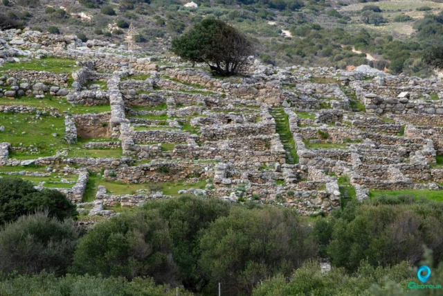
Gournia Minoan settlement
Gournia, a Minoan town on Crete's north coast, presents a complete example of a small settlement.
Excavations, starting with Harriet Boyd Hawes, reveal houses, a palace, and a street network, reflecting Minoan urbanism. The site's history spans from the Neolithic to Late Minoan periods, witnessing growth, destruction, and limited reoccupation. Discoveries include artifacts, cemeteries (Sphoungaras, North), and architectural features like the 'Shore House,' suggesting maritime connections. The town's layout, with a main street and organized blocks, highlights urban planning. Gournia's cultural and economic context includes regional trade and religious practices. Ongoing projects reexamine its architecture, offering insights into Minoan civilization and its connections to other Aegean settlements.
Papadiokampos Minoan House
Minoan harbor town on Crete's coast between Mochlos and Petras, active from Protopalatial to Late Minoan I (LM I). Linked to nearby Petras, it suffered destruction in LM IB, possibly due to the Thera eruption. Excavations, particularly of House A.1, uncovered a two-story building, ceramics like cooking pots and evidence of seafood soup, stone tools (querns, pounders), and metal artifacts, suggesting sudden abandonment. Residents practiced farming (grapes, cereals, olives), fishing (notably shellfish), and wine production. Evidence from House B.1 points to metal and textile trade, indicating social stratification. Craft specialization included purple dye production.
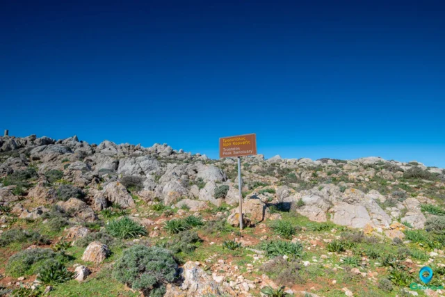
Traostalos Peak Sanctuary
The Traostalos Peak Sanctuary, located 3.2 km from the palace of Zakros in Crete, dates back to the Final Neolithic period (1700-1450 BCE). The site, partially excavated, features votive offerings, terracotta figurines, animal replicas, a clay model of a ship, bronze needles, gold ribbons, various vessels, and Linear A inscriptions. The sanctuary's decline in LM IB coincides with the rise of the Zakros palace and other peak sanctuaries' abandonment, possibly due to ideological shifts, earthquakes, or the Thera eruption. The site's lack of monumental dedications or evidence of large-scale animal consumption suggests less political influence compared to other peak sanctuaries. The construction of the Zakros palace marked a shift towards a more hierarchical social and political organization, contrasting with the public ceremonies at Traostalos. The sanctuary's abandonment after the wider area's unification under the palace indicates its connection to the early stages of state formation in Minoan Crete.
Pelekita Cave, Zakros
Pelekita Cave, on Crete's east coast, features Neolithic and Minoan finds. Excavations reveal pottery, tools, and animal bones, detailing early Aegean life. Neolithic strata include debates on dating and regional connections to the Cyclades and Anatolia. The cave's use spanned from the Paleolithic to the Minoan period, with a volcanic ash layer linking it to the Thera eruption. Domestic features like hearths and a possible sheep-pen suggest varied uses. Ongoing analysis aims to clarify the cave’s chronology and significance, showing its role in understanding Crete’s prehistory. The cave contains five chambers, stalactites, stalagmites, and a freshwater source.
Livari Minoan coastal settlement
Livari, located on Crete's southeastern coast, is a significant archaeological site with evidence of human occupation from the Mesolithic to Venetian periods. The area, characterized by a coastal plain and low hills, includes sites like Cheromylia, Kastrokephalaki, and Chlios, revealing Minoan settlements and early hunter-gatherer activities. Archaeological campaigns have documented lithic assemblages from the Mesolithic, Bronze Age remains, and structures from the Classical/Hellenistic and Venetian eras, including a possible watchtower. Despite poor preservation, erosion, and vegetation cover, Livari provides crucial insights into early human activity, Minoan civilization, and cultural transitions in the Aegean. Studies document topography, structures, and landmarks, correcting misconceptions and emphasizing the site's importance for understanding Crete's broader archaeological context.
Azoria ancient settlement
Azoria, located on Crete, is an archaeological site revealing urban development from the Bronze Age to the Archaic period. Notably, it grew into a regional center during the Early Iron Age and reached its peak in the 6th century BC. Excavations show organized city planning, monumental buildings, and a shift from dispersed villages to a centralized settlement. The site experienced destruction by fire in the 5th century BC, followed by limited Hellenistic reoccupation. Azoria's stratification and botanical/faunal studies provide insights into socioeconomic changes and landscape transformations. Research highlights its role in Crete's urbanization, revealing changes in settlement patterns and social structures. The site's strategic location and architectural renovations underscore its importance in understanding the development of the Cretan polis.
Vori, Siteia
Vori, a small village in Sitia, Crete, on the Sitia-Lithines road, is an almost deserted settlement with historical roots. Its stone houses feature unique clay pithos chimneys, characteristic of Sitia villages. The village center boasts the picturesque Michael Archangel church, while Agia Paraskevi, a Byzantine cemetery church, lies just outside. Vori's history includes Venetian rule and varying population numbers over the centuries. Despite its small size and dwindling population, Vori retains its charm, showcasing traditional architecture with stone doors and carvings, offering a glimpse into Crete's past.
Kalo Chorio, Siteia
Kalo Chorio (meaning "Good Village") is a remote village in Lasithi, Crete, located in the mountains near Sitia. First mentioned in 1881, its history likely dates back further, potentially linked to the Venetian and Turkish periods. The village has seen a significant population decline, with only 9 residents in 2011. Kalo Chorio offers a glimpse into authentic Cretan life.
Mesa Apidi, Siteia
Mesa Apidi, a village in Lasithi, Crete, near Sitia, has a history dating back to at least 1925. Not mentioned in the 1583 census, it likely developed after the 16th century. The name derives from the pear tree, though none grow there today. The village became its own community in 1928. Now part of the Apidia community within the Sitia municipality, it comprises Mesa Apidi, Goudouras, Exo Apidi, and Kalos Lakkos. The semi-mountainous terrain is used for crops and pastures. Population data shows a decline from 179 residents in 1881 to around 20 in 2021.
Agia Triada, Siteia
Agia Triada (Agia Trias), a village in Siteia, eastern Crete, has a history dating back to the Minoan era, with archaeological finds at PetroKopio, Stalos, and Alogara cave. Formerly known as Tso, its name changed in 1920. The village, not mentioned in Venetian censuses, likely repopulated in the 16th-17th centuries after pirate destruction. First recorded in the 1834 Egyptian census, it had 25 Christian families. By 1881, its population reached 158. The village's economy is based on agriculture and fishing.
Mochlos Minoan Settlement and Port
Mochlos, a small islet off Crete, was a significant Minoan port city with a long history. Settled from the Early Minoan period, it flourished in trade, particularly during EM III, evidenced by sophisticated crafts like pottery and metalwork. The site shows social stratification through its tombs. A decline occurred in the Middle Minoan period, but Mochlos revived in the Neopalatial period with a smaller town and ceremonial buildings. The town was destroyed in LM IB, though the site was reoccupied by Mycenaeans. Mochlos later became a major center for amphora production in the Roman era, exporting wine across the Mediterranean. Excavations continue to reveal insights into Minoan life and trade.
Perivolakia, Siteia
Perivolakia, a small village in Sitia, Lasithi, Crete, consists of two settlements, Epano and Kato Perivolakia. Near Kato Perivolakia lies Pezoulas. The village is known for the Perivolakia or Kapsa Gorge, a 4.5km gorge with steep walls, and the nearby pre-Minoan Vournoferto cave with hunting scenes. Historically, Perivolakia is first mentioned in the 1881 census. Other sights include the deserted monastery of Panagia, caves in Kalo Nero, the Monastery of Kapsa, the old church of Agioi Saranta, beaches like Ammoudi, and the deserted settlement of Pezoulas. The village had 21 residents in 2011.
Moni Kapsa Monastery
Moni Kapsa, an Eastern Orthodox monastery in southeastern Crete, Greece, is dedicated to Saint John the Baptist. Situated in the Lasithi region, near Pervolakia Gorge and overlooking the Libyan Sea, the monastery features a unique cave-like church with pebble mosaics. Its history spans from the Byzantine period, with evidence of hermits and monks residing there, through Venetian rule, pirate raids, and Ottoman influence. It was revived in the 19th century by Iosif Gerontogiannis, a local hermit later venerated as a saint. The complex includes monks' cells, a guesthouse, and a dining hall, built on four levels. The church's north wall contains paintings from 1552-1809, remnants of an older structure. The nearby Pervolakia Gorge offers hiking trails and unique flora. The monastery played a role in WWII, assisting Allied forces. It was restored in the early 2000s and remains an active monastery.